Dalías geodata
Dalías (Andalusia) is a populated place; located in Spain in Europe/Madrid (GMT+2) time zone. With population of 3,688 people, there are 1541 cities with bigger population in this country. Compared to other cities in Spain, 96.6% of cities are located further ↑North; 56.4% of cities are located further ←West and 67.7% of cities have higher elevation than Dalías. Note1


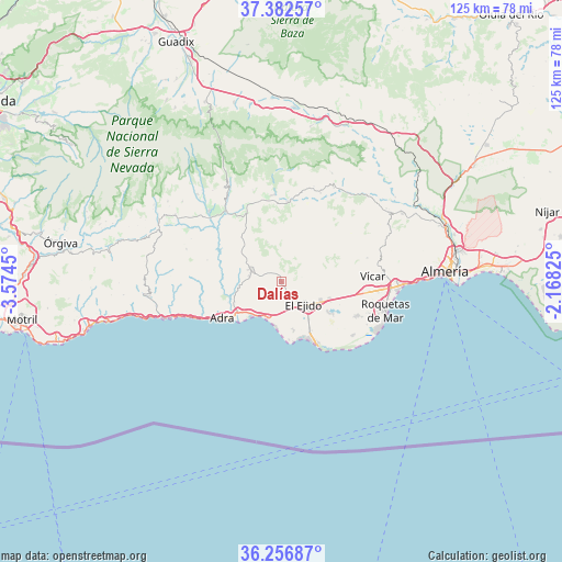
Dalías GPS coordinates[2]
36° 49' 18.444" North, 2° 52' 16.968" West
| Map corner | latitude | longitude |
|---|---|---|
| Upper-left | 37.38257°, | -3.5745° |
| Center: | 36.82179°, | -2.87138° |
| Lower-right: | 36.25687°, | -2.16825° |
| Map W x H: | 125.2×125.2 km | = 77.8×77.8mi |
| max Lat: | 43.74134° ⇑96.6% North |
| Dalías: | 36.82179° |
| min Lat: | ⇓3.4% South 27.64134° |
| min Long | Dalías | max Long |
| -18.00367° | -2.87138° | 4.2899° |
| W 56.4%⇐ | ⇒43.6% E |
Elevation
Elevation of Dalías is 422 m = 1385 ft, and this is 176 m = 577 ft below average elevation for this country.
| Max E: |
1682 m = 5518 ft | 67.7% |
| Avg. | 598 m = 1962 ft | |
| Dalías | 422 m = 1385 ft | |
Min E: |
0 m = 0 ft | 32.3% |
See also: Spain elevation on elevation.city.
Geographical zone
Dalías is located in North temperate zone (between Tropic of Cancer and the Arctic Circle). Distance of this Northern Tropic circle is 1488.3 km =924.8 mi to South.| Distance of | km | miles | from Dalías |
|---|---|---|---|
| North Pole | 5912.9 | 3674.1 | to North |
| Arctic Circle | 3307 | 2054.9 | to North |
| Tropic Cancer | 1488.3 | 924.8 | to South |
| Equator | 4094.2 | 2544 | to South |


Nearby cities:
15 places around Dalías: (largest is in red/bold)
• Adra
15.5 km =9.6 mi,  238°
238°
• Alcolea
18.8 km =11.7 mi,  334°
334°
• Almócita
21.4 km =13.3 mi,  19°
19°
• Balanegra
8.8 km =5.5 mi,  202°
202°
• Beires
22.4 km =13.9 mi, 18°
• Berja
7.5 km =4.7 mi,  291°
291°
• Darrícal
17.8 km =11.1 mi,  307°
307°
• El Ejido
7.2 km =4.5 mi,  135°
135°
• Fondón
17.6 km =10.9 mi,  3°
3°
• Félix
19.7 km =12.2 mi,  74°
74°
• La Gangosa Vistasol
22.3 km =13.9 mi,  94°
94°
• Laujar de Andarax
19.4 km =12.1 mi,  355°
355°
• Murtas
22.3 km =13.9 mi, 288°
• Padules
21.4 km =13.3 mi, 23°
• Vícar
20.4 km =12.7 mi, 86°
Sources, notices
• [Note1] Compared only with cities in Spain existing in our database
• [Src1] Map data: © OpenStreetMap contributors (CC-BY-SA)
• [Src2] Other city data from geonames.org with taken over terms of usage.
• [Src3] Geographical zone / Annual Mean Temperature by Robert A. Rohde @ Wikipedia
