Berja geodata
Berja (Andalusia) is a seat of a third-order administrative division; located in Spain in Europe/Madrid (GMT+2) time zone. With population of 15,035 people, there are 617 cities with bigger population in this country. Compared to other cities in Spain, 96.4% of cities are located further ↑North; 55.3% of cities are located further ←West and 72.6% of cities have higher elevation than Berja. Note1


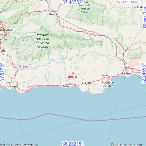
Berja GPS coordinates[2]
36° 50' 48.948" North, 2° 56' 58.776" West
| Map corner | latitude | longitude |
|---|---|---|
| Upper-left | 37.40752°, | -3.65278° |
| Center: | 36.84693°, | -2.94966° |
| Lower-right: | 36.28219°, | -2.24653° |
| Map W x H: | 125.1×125.1 km | = 77.7×77.7mi |
| max Lat: | 43.74134° ⇑96.4% North |
| Berja: | 36.84693° |
| min Lat: | ⇓3.6% South 27.64134° |
| min Long | Berja | max Long |
| -18.00367° | -2.94966° | 4.2899° |
| W 55.3%⇐ | ⇒44.7% E |
Elevation
Elevation of Berja is 338 m = 1109 ft, and this is 260 m = 853 ft below average elevation for this country.
| Max E: |
1682 m = 5518 ft | 72.6% |
| Avg. | 598 m = 1962 ft | |
| Berja | 338 m = 1109 ft | |
Min E: |
0 m = 0 ft | 27.4% |
See also: Spain elevation on elevation.city.
Geographical zone
Berja is located in North temperate zone (between Tropic of Cancer and the Arctic Circle). Distance of this Northern Tropic circle is 1491.1 km =926.5 mi to South.| Distance of | km | miles | from Berja |
|---|---|---|---|
| North Pole | 5910.1 | 3672.4 | to North |
| Arctic Circle | 3304.2 | 2053.1 | to North |
| Tropic Cancer | 1491.1 | 926.5 | to South |
| Equator | 4097 | 2545.8 | to South |


Nearby cities:
15 places around Berja: (largest is in red/bold)
• Adra
12.5 km =7.8 mi,  210°
210°
• Alcolea
14.2 km =8.8 mi,  355°
355°
• Almócita
22.4 km =13.9 mi,  39°
39°
• Balanegra
11.5 km =7.1 mi,  161°
161°
• Bayárcal
20.8 km =12.9 mi,  348°
348°
• Dalías
7.5 km =4.7 mi,  111°
111°
• Darrícal
10.8 km =6.7 mi,  318°
318°
• El Ejido
14.4 km =8.9 mi,  123°
123°
• Fondón
16.8 km =10.4 mi,  28°
28°
• Laujar de Andarax
17.3 km =10.7 mi,  17°
17°
• Murtas
14.8 km =9.2 mi,  286°
286°
• Padules
23 km =14.3 mi, 42°
• Paterna del Río
19.5 km =12.1 mi, 359°
• Ugíjar
15.8 km =9.8 mi, 323°
• Válor
20.4 km =12.7 mi, 324°
Sources, notices
• [Note1] Compared only with cities in Spain existing in our database
• [Src1] Map data: © OpenStreetMap contributors (CC-BY-SA)
• [Src2] Other city data from geonames.org with taken over terms of usage.
• [Src3] Geographical zone / Annual Mean Temperature by Robert A. Rohde @ Wikipedia
