Agrón geodata
Agrón (Andalusia) is a seat of a third-order administrative division; located in Spain in Europe/Madrid (GMT+2) time zone. With population of 300 people, there are 4499 cities with bigger population in this country. Compared to other cities in Spain, 95% of cities are located further ↑North; 57.3% of cities are located further →East and 91.2% of cities have lower elevation than Agrón. Note1


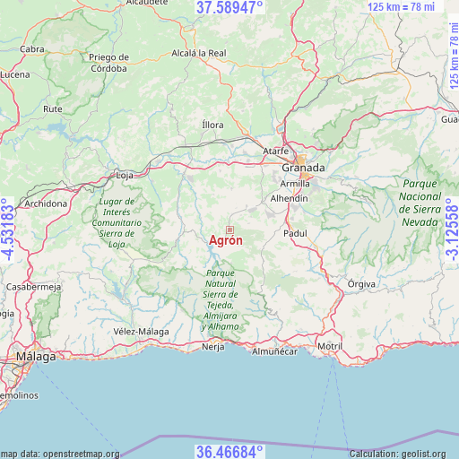
Agrón GPS coordinates[2]
37° 1' 48.828" North, 3° 49' 43.32" West
| Map corner | latitude | longitude |
|---|---|---|
| Upper-left | 37.58947°, | -4.53183° |
| Center: | 37.03023°, | -3.8287° |
| Lower-right: | 36.46684°, | -3.12558° |
| Map W x H: | 124.8×124.8 km | = 77.5×77.5mi |
| max Lat: | 43.74134° ⇑95% North |
| Agrón: | 37.03023° |
| min Lat: | ⇓5% South 27.64134° |
| min Long | Agrón | max Long |
| -18.00367° | -3.8287° | 4.2899° |
| W 42.7%⇐ | ⇒57.3% E |
Elevation
Elevation of Agrón is 1051 m = 3448 ft, and this is 453 m = 1486 ft above average elevation for this country.
| Max E: |
1682 m = 5518 ft | 8.8% |
| Agrón | 1051 m 3448 ft | |
| Avg. | 598 m = 1962 ft | |
Min E: |
0 m = 0 ft | 91.2% |
See also: Spain elevation on elevation.city.
Geographical zone
Agrón is located in North temperate zone (between Tropic of Cancer and the Arctic Circle). Distance of this Northern Tropic circle is 1511.5 km =939.2 mi to South.| Distance of | km | miles | from Agrón |
|---|---|---|---|
| North Pole | 5889.7 | 3659.7 | to North |
| Arctic Circle | 3283.8 | 2040.5 | to North |
| Tropic Cancer | 1511.5 | 939.2 | to South |
| Equator | 4117.4 | 2558.4 | to South |


Nearby cities:
15 places around Agrón: (largest is in red/bold)
• Alhama de Granada
14.5 km =9 mi,  259°
259°
• Alhendín
18.4 km =11.4 mi,  61°
61°
• Arenas del Rey
9.9 km =6.2 mi,  215°
215°
• Chauchina
19.5 km =12.1 mi,  15°
15°
• Chimeneas
11.3 km =7 mi,  3°
3°
• Cijuela
18.7 km =11.6 mi, 4°
• Cúllar-Vega
19.6 km =12.2 mi,  45°
45°
• Escúzar
7 km =4.3 mi, 59°
• Jayena
9 km =5.6 mi,  176°
176°
• Las Gabias
18.3 km =11.4 mi, 50°
• Láchar
18.3 km =11.4 mi,  358°
358°
• Moraleda de Zafayona
19.4 km =12.1 mi,  321°
321°
• Otura
18.5 km =11.5 mi,  69°
69°
• Padul
17.9 km =11.1 mi,  91°
91°
• Ventas de Huelma
4.3 km =2.7 mi,  10°
10°
Sources, notices
• [Note1] Compared only with cities in Spain existing in our database
• [Src1] Map data: © OpenStreetMap contributors (CC-BY-SA)
• [Src2] Other city data from geonames.org with taken over terms of usage.
• [Src3] Geographical zone / Annual Mean Temperature by Robert A. Rohde @ Wikipedia
