Sarratella geodata
Sarratella (Valencia) is a seat of a third-order administrative division; located in Spain in Europe/Madrid (GMT+2) time zone. With population of 93 people, there are 6020 cities with bigger population in this country. Compared to other cities in Spain, 65.6% of cities are located further ↑North; 87.2% of cities are located further ←West and 64.4% of cities have lower elevation than Sarratella. Note1


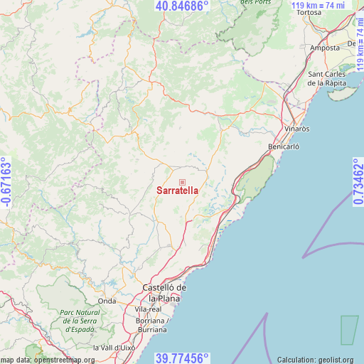
Sarratella GPS coordinates[2]
40° 18' 46.224" North, 0° 1' 53.4" East
| Map corner | latitude | longitude |
|---|---|---|
| Upper-left | 40.84686°, | -0.67163° |
| Center: | 40.31284°, | 0.0315° |
| Lower-right: | 39.77456°, | 0.73462° |
| Map W x H: | 119.2×119.2 km | = 74.1×74.1mi |
| max Lat: | 43.74134° ⇑65.6% North |
| Sarratella: | 40.31284° |
| min Lat: | ⇓34.4% South 27.64134° |
| min Long | Sarratella | max Long |
| -18.00367° | 0.0315° | 4.2899° |
| W 87.2%⇐ | ⇒12.8% E |
Elevation
Elevation of Sarratella is 774 m = 2539 ft, and this is 176 m = 577 ft above average elevation for this country.
| Max E: |
1682 m = 5518 ft | 35.6% |
| Sarratella | 774 m 2539 ft | |
| Avg. | 598 m = 1962 ft | |
Min E: |
0 m = 0 ft | 64.4% |
See also: Spain elevation on elevation.city.
Geographical zone
Sarratella is located in North temperate zone (between Tropic of Cancer and the Arctic Circle). Distance of this Northern Tropic circle is 1876.4 km =1165.9 mi to South.| Distance of | km | miles | from Sarratella |
|---|---|---|---|
| North Pole | 5524.7 | 3432.9 | to North |
| Arctic Circle | 2918.8 | 1813.7 | to North |
| Tropic Cancer | 1876.4 | 1165.9 | to South |
| Equator | 4482.4 | 2785.2 | to South |


Nearby cities:
15 places around Sarratella: (largest is in red/bold)
• Adzaneta
20.2 km =12.6 mi,  237°
237°
• Albocàsser
4.1 km =2.5 mi,  2°
2°
• Alcalà de Xivert
17.2 km =10.7 mi,  94°
94°
• Ares del Maestre
21.2 km =13.2 mi,  319°
319°
• Benafigos
20.7 km =12.9 mi,  258°
258°
• Benassal
16.2 km =10.1 mi,  296°
296°
• Benlloch
11.4 km =7.1 mi,  181°
181°
• Cabanes
17.5 km =10.9 mi, 176°
• Catí
17.7 km =11 mi,  357°
357°
• Cuevas de Vinromá
7.6 km =4.7 mi, 92°
• Culla
16.9 km =10.5 mi,  278°
278°
• Salsadella
16.9 km =10.5 mi,  46°
46°
• Sierra-Engarcerán
6.5 km =4 mi,  221°
221°
• Tirig
12.9 km =8 mi,  17°
17°
• Torreblanca
17.4 km =10.8 mi,  126°
126°
Sources, notices
• [Note1] Compared only with cities in Spain existing in our database
• [Src1] Map data: © OpenStreetMap contributors (CC-BY-SA)
• [Src2] Other city data from geonames.org with taken over terms of usage.
• [Src3] Geographical zone / Annual Mean Temperature by Robert A. Rohde @ Wikipedia
