Sierra-Engarcerán geodata
Sierra-Engarcerán (Valencia) is a populated place; located in Spain in Europe/Madrid (GMT+2) time zone. With population of 1,068 people, there are 2852 cities with bigger population in this country. Compared to other cities in Spain, 66.2% of cities are located further ↑North; 86.9% of cities are located further ←West and 61.2% of cities have lower elevation than Sierra-Engarcerán. Note1
Administrative division(s):
- Level 1: Valencia
- Level 2: Província de Castelló
- Level 3: Sierra Engarcerán


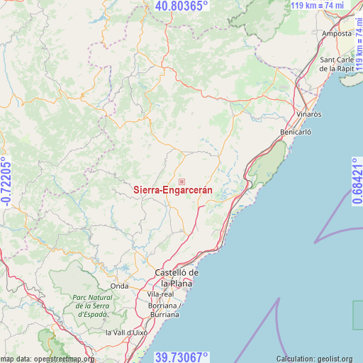
Sierra-Engarcerán GPS coordinates[2]
40° 16' 9.444" North, 0° 1' 8.112" West
| Map corner | latitude | longitude |
|---|---|---|
| Upper-left | 40.80365°, | -0.72205° |
| Center: | 40.26929°, | -0.01892° |
| Lower-right: | 39.73067°, | 0.68421° |
| Map W x H: | 119.3×119.3 km | = 74.1×74.1mi |
| max Lat: | 43.74134° ⇑66.2% North |
| Sierra-Engarcerán: | 40.26929° |
| min Lat: | ⇓33.8% South 27.64134° |
| min Long | Sierra-Engarcer | max Long |
| -18.00367° | -0.01892° | 4.2899° |
| W 86.9%⇐ | ⇒13.1% E |
Elevation
Elevation of Sierra-Engarcerán is 752 m = 2467 ft, and this is 154 m = 505 ft above average elevation for this country.
| Max E: |
1682 m = 5518 ft | 38.8% |
| Sierra-Engarcerán | 752 m 2467 ft | |
| Avg. | 598 m = 1962 ft | |
Min E: |
0 m = 0 ft | 61.2% |
See also: Spain elevation on elevation.city.
Geographical zone
Sierra-Engarcerán is located in North temperate zone (between Tropic of Cancer and the Arctic Circle). Distance of this Northern Tropic circle is 1871.6 km =1163 mi to South.| Distance of | km | miles | from Sierra-Engarcerán |
|---|---|---|---|
| North Pole | 5529.5 | 3435.9 | to North |
| Arctic Circle | 2923.6 | 1816.6 | to North |
| Tropic Cancer | 1871.6 | 1163 | to South |
| Equator | 4477.5 | 2782.2 | to South |


Nearby cities:
15 places around Sierra-Engarcerán: (largest is in red/bold)
• Adzaneta
14.1 km =8.8 mi,  245°
245°
• Albocàsser
10 km =6.2 mi,  26°
26°
• Benafigos
16 km =9.9 mi,  272°
272°
• Benassal
15.7 km =9.8 mi,  319°
319°
• Benlloch
7.6 km =4.7 mi,  148°
148°
• Cabanes
13.7 km =8.5 mi,  157°
157°
• Costur
21.2 km =13.2 mi,  218°
218°
• Cuevas de Vinromá
12.7 km =7.9 mi,  69°
69°
• Culla
14.5 km =9 mi,  300°
300°
• Puebla Tornesa
18.6 km =11.6 mi,  175°
175°
• Sarratella
6.5 km =4 mi,  41°
41°
• Tirig
19 km =11.8 mi, 25°
• Torreblanca
19.1 km =11.9 mi,  106°
106°
• Useras
17.6 km =10.9 mi,  225°
225°
• Villafamés
17.2 km =10.7 mi,  188°
188°
Sources, notices
• [Note1] Compared only with cities in Spain existing in our database
• [Src1] Map data: © OpenStreetMap contributors (CC-BY-SA)
• [Src2] Other city data from geonames.org with taken over terms of usage.
• [Src3] Geographical zone / Annual Mean Temperature by Robert A. Rohde @ Wikipedia
