Benlloch geodata
Benlloch (Valencia) is a seat of a third-order administrative division; located in Spain in Europe/Madrid (GMT+2) time zone. With population of 841 people, there are 3145 cities with bigger population in this country. Compared to other cities in Spain, 67% of cities are located further ↑North; 87.2% of cities are located further ←West and 73.9% of cities have higher elevation than Benlloch. Note1


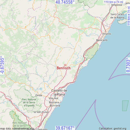
Benlloch GPS coordinates[2]
40° 12' 38.7" North, 0° 1' 37.812" East
| Map corner | latitude | longitude |
|---|---|---|
| Upper-left | 40.74558°, | -0.67595° |
| Center: | 40.21075°, | 0.02717° |
| Lower-right: | 39.67167°, | 0.7303° |
| Map W x H: | 119.4×119.4 km | = 74.2×74.2mi |
| max Lat: | 43.74134° ⇑67% North |
| Benlloch: | 40.21075° |
| min Lat: | ⇓33% South 27.64134° |
| min Long | Benlloch | max Long |
| -18.00367° | 0.02717° | 4.2899° |
| W 87.2%⇐ | ⇒12.8% E |
Elevation
Elevation of Benlloch is 317 m = 1040 ft, and this is 281 m = 922 ft below average elevation for this country.
| Max E: |
1682 m = 5518 ft | 73.9% |
| Avg. | 598 m = 1962 ft | |
| Benlloch | 317 m = 1040 ft | |
Min E: |
0 m = 0 ft | 26.1% |
See also: Spain elevation on elevation.city.
Geographical zone
Benlloch is located in North temperate zone (between Tropic of Cancer and the Arctic Circle). Distance of this Northern Tropic circle is 1865.1 km =1158.9 mi to South.| Distance of | km | miles | from Benlloch |
|---|---|---|---|
| North Pole | 5536 | 3439.9 | to North |
| Arctic Circle | 2930.2 | 1820.7 | to North |
| Tropic Cancer | 1865.1 | 1158.9 | to South |
| Equator | 4471 | 2778.1 | to South |


Nearby cities:
15 places around Benlloch: (largest is in red/bold)
• Adzaneta
16.8 km =10.4 mi,  272°
272°
• Albocàsser
15.5 km =9.6 mi,  1°
1°
• Alcalà de Xivert
20.1 km =12.5 mi,  60°
60°
• Benicàssim
18.2 km =11.3 mi,  169°
169°
• Borriol
20.5 km =12.7 mi,  203°
203°
• Cabanes
6.2 km =3.9 mi, 167°
• Costur
19.9 km =12.4 mi,  239°
239°
• Cuevas de Vinromá
13.6 km =8.5 mi,  35°
35°
• Oropesa del Mar
16.4 km =10.2 mi,  143°
143°
• Puebla Tornesa
12.3 km =7.6 mi,  191°
191°
• Sarratella
11.4 km =7.1 mi, 1°
• Sierra-Engarcerán
7.6 km =4.7 mi,  328°
328°
• Torreblanca
14.4 km =8.9 mi,  85°
85°
• Useras
17.4 km =10.8 mi,  250°
250°
• Villafamés
12.3 km =7.6 mi,  212°
212°
Sources, notices
• [Note1] Compared only with cities in Spain existing in our database
• [Src1] Map data: © OpenStreetMap contributors (CC-BY-SA)
• [Src2] Other city data from geonames.org with taken over terms of usage.
• [Src3] Geographical zone / Annual Mean Temperature by Robert A. Rohde @ Wikipedia
