Orísoain geodata
Orísoain (Navarre) is a seat of a third-order administrative division; located in Spain in Europe/Madrid (GMT+2) time zone. With population of 83 people, there are 6106 cities with bigger population in this country. Compared to other cities in Spain, 89.5% of cities are located further ↓South; 72% of cities are located further ←West and 56% of cities have higher elevation than Orísoain. Note1


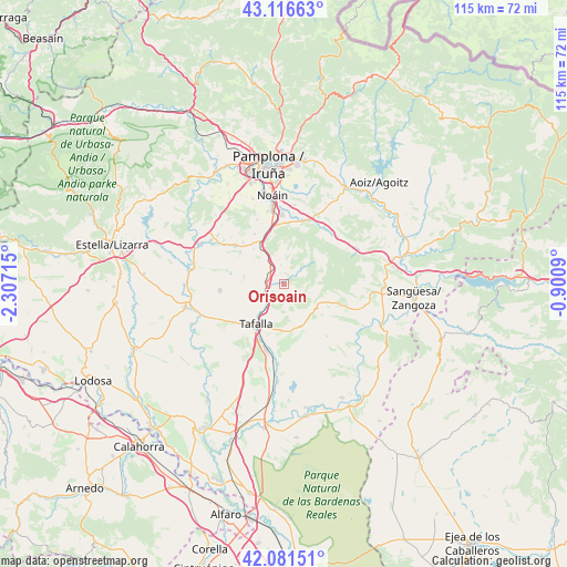
Orísoain GPS coordinates[2]
42° 36' 4.392" North, 1° 36' 14.508" West
| Map corner | latitude | longitude |
|---|---|---|
| Upper-left | 43.11663°, | -2.30715° |
| Center: | 42.60122°, | -1.60403° |
| Lower-right: | 42.08151°, | -0.9009° |
| Map W x H: | 115.1×115.1 km | = 71.5×71.5mi |
| max Lat: | 43.74134° ⇑10.5% North |
| Orísoain: | 42.60122° |
| min Lat: | ⇓89.5% South 27.64134° |
| min Long | Orísoain | max Long |
| -18.00367° | -1.60403° | 4.2899° |
| W 72%⇐ | ⇒28% E |
Elevation
Elevation of Orísoain is 582 m = 1909 ft, and this is 16 m = 52 ft below average elevation for this country.
| Max E: |
1682 m = 5518 ft | 56% |
| Avg. | 598 m = 1962 ft | |
| Orísoain | 582 m = 1909 ft | |
Min E: |
0 m = 0 ft | 44% |
See also: Spain elevation on elevation.city.
Geographical zone
Orísoain is located in North temperate zone (between Tropic of Cancer and the Arctic Circle). Distance of this Northern Tropic circle is 2130.9 km =1324.1 mi to South.| Distance of | km | miles | from Orísoain |
|---|---|---|---|
| North Pole | 5270.3 | 3274.8 | to North |
| Arctic Circle | 2664.4 | 1655.6 | to North |
| Tropic Cancer | 2130.9 | 1324.1 | to South |
| Equator | 4736.8 | 2943.3 | to South |


Nearby cities:
15 places around Orísoain: (largest is in red/bold)
• Artajona
13.3 km =8.3 mi,  263°
263°
• Añorbe
11 km =6.8 mi,  304°
304°
• Barásoain
3.5 km =2.2 mi,  273°
273°
• Enériz
12.8 km =8 mi,  307°
307°
• Eslava
12.5 km =7.8 mi,  108°
108°
• Garínoain
3.3 km =2.1 mi, 268°
• Lerga
9.2 km =5.7 mi, 113°
• Monreal
13.9 km =8.6 mi,  34°
34°
• Olóriz
3.8 km =2.4 mi,  349°
349°
• Pueyo
5.4 km =3.4 mi,  222°
222°
• San Martín de Unx
9.2 km =5.7 mi,  157°
157°
• Tafalla
10.1 km =6.3 mi,  214°
214°
• Tirapu
10.2 km =6.3 mi, 307°
• Ujué
14.1 km =8.8 mi,  142°
142°
• Unzué
6 km =3.7 mi,  342°
342°
Sources, notices
• [Note1] Compared only with cities in Spain existing in our database
• [Src1] Map data: © OpenStreetMap contributors (CC-BY-SA)
• [Src2] Other city data from geonames.org with taken over terms of usage.
• [Src3] Geographical zone / Annual Mean Temperature by Robert A. Rohde @ Wikipedia
