Chantada geodata
Chantada (Galicia) is a seat of a third-order administrative division; located in Spain in Europe/Madrid (GMT+2) time zone. With population of 9,339 people, there are 884 cities with bigger population in this country. Compared to other cities in Spain, 89.7% of cities are located further ↓South; 95.9% of cities are located further →East and 62.6% of cities have higher elevation than Chantada. Note1


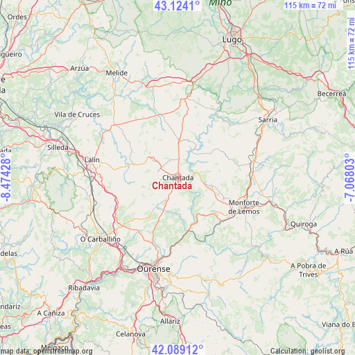
Chantada GPS coordinates[2]
42° 36' 31.536" North, 7° 46' 16.14" West
| Map corner | latitude | longitude |
|---|---|---|
| Upper-left | 43.1241°, | -8.47428° |
| Center: | 42.60876°, | -7.77115° |
| Lower-right: | 42.08912°, | -7.06803° |
| Map W x H: | 115.1×115.1 km | = 71.5×71.5mi |
| max Lat: | 43.74134° ⇑10.3% North |
| Chantada: | 42.60876° |
| min Lat: | ⇓89.7% South 27.64134° |
| min Long | Chantada | max Long |
| -18.00367° | -7.77115° | 4.2899° |
| W 4.1%⇐ | ⇒95.9% E |
Elevation
Elevation of Chantada is 491 m = 1611 ft, and this is 107 m = 351 ft below average elevation for this country.
| Max E: |
1682 m = 5518 ft | 62.6% |
| Avg. | 598 m = 1962 ft | |
| Chantada | 491 m = 1611 ft | |
Min E: |
0 m = 0 ft | 37.4% |
See also: Spain elevation on elevation.city.
Geographical zone
Chantada is located in North temperate zone (between Tropic of Cancer and the Arctic Circle). Distance of this Northern Tropic circle is 2131.7 km =1324.6 mi to South.| Distance of | km | miles | from Chantada |
|---|---|---|---|
| North Pole | 5269.4 | 3274.3 | to North |
| Arctic Circle | 2663.5 | 1655 | to North |
| Tropic Cancer | 2131.7 | 1324.6 | to South |
| Equator | 4737.6 | 2943.8 | to South |


Nearby cities:
15 places around Chantada: (largest is in red/bold)
• Carballedo
10.7 km =6.6 mi,  205°
205°
• Castro
23.3 km =14.5 mi,  41°
41°
• Cea
23.1 km =14.4 mi,  229°
229°
• Coles
23.8 km =14.8 mi,  192°
192°
• Dozón
20.3 km =12.6 mi,  261°
261°
• Luintra
22.4 km =13.9 mi,  170°
170°
• Monforte de Lemos
23.2 km =14.4 mi,  114°
114°
• Monterroso
21.1 km =13.1 mi,  345°
345°
• Nogueira de Ramuín
21.4 km =13.3 mi,  175°
175°
• Pantón
17.4 km =10.8 mi,  126°
126°
• Piñor
22.3 km =13.9 mi,  237°
237°
• Rodeiro
15.8 km =9.8 mi,  287°
287°
• Sober
22.3 km =13.9 mi,  137°
137°
• Taboada
10.9 km =6.8 mi,  337°
337°
• Vilamarín
18.8 km =11.7 mi, 211°
Sources, notices
• [Note1] Compared only with cities in Spain existing in our database
• [Src1] Map data: © OpenStreetMap contributors (CC-BY-SA)
• [Src2] Other city data from geonames.org with taken over terms of usage.
• [Src3] Geographical zone / Annual Mean Temperature by Robert A. Rohde @ Wikipedia
