Ourol geodata
Ourol (Galicia) is a populated place; located in Spain in Europe/Madrid (GMT+2) time zone. With population of 1,328 people, there are 2617 cities with bigger population in this country. Compared to other cities in Spain, 93.4% of cities are located further ↓South; 95.6% of cities are located further →East and 64.6% of cities have higher elevation than Ourol. Note1


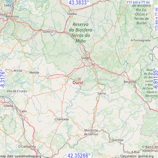
Ourol GPS coordinates[2]
42° 52' 12.468" North, 7° 36' 52.092" West
| Map corner | latitude | longitude |
|---|---|---|
| Upper-left | 43.3833°, | -8.3176° |
| Center: | 42.87013°, | -7.61447° |
| Lower-right: | 42.35266°, | -6.91135° |
| Map W x H: | 114.6×114.6 km | = 71.2×71.2mi |
| max Lat: | 43.74134° ⇑6.6% North |
| Ourol: | 42.87013° |
| min Lat: | ⇓93.4% South 27.64134° |
| min Long | Ourol | max Long |
| -18.00367° | -7.61447° | 4.2899° |
| W 4.4%⇐ | ⇒95.6% E |
Elevation
Elevation of Ourol is 465 m = 1526 ft, and this is 133 m = 436 ft below average elevation for this country.
| Max E: |
1682 m = 5518 ft | 64.6% |
| Avg. | 598 m = 1962 ft | |
| Ourol | 465 m = 1526 ft | |
Min E: |
0 m = 0 ft | 35.4% |
See also: Spain elevation on elevation.city.
Geographical zone
Ourol is located in North temperate zone (between Tropic of Cancer and the Arctic Circle). Distance of this Northern Tropic circle is 2160.8 km =1342.7 mi to South.| Distance of | km | miles | from Ourol |
|---|---|---|---|
| North Pole | 5240.4 | 3256.2 | to North |
| Arctic Circle | 2634.5 | 1637 | to North |
| Tropic Cancer | 2160.8 | 1342.7 | to South |
| Equator | 4766.7 | 2961.9 | to South |


Nearby cities:
15 places around Ourol: (largest is in red/bold)
• Castro
11.8 km =7.3 mi,  167°
167°
• Corgo
17 km =10.6 mi,  61°
61°
• Friol
23.3 km =14.5 mi,  320°
320°
• Guntín
6.6 km =4.1 mi,  286°
286°
• Lugo
16.3 km =10.1 mi,  17°
17°
• Láncara
22.6 km =14 mi,  91°
91°
• Monterroso
19.9 km =12.4 mi,  244°
244°
• O Páramo
27.1 km =16.8 mi,  70°
70°
• Outeiro de Rei
25.8 km =16 mi,  359°
359°
• Paradela
12.1 km =7.5 mi,  161°
161°
• Portomarín
7.1 km =4.4 mi,  181°
181°
• Rábade
27.5 km =17.1 mi, 359°
• Samos
28.2 km =17.5 mi,  123°
123°
• Sarria
19.1 km =11.9 mi, 121°
• Taboada
25.5 km =15.8 mi,  221°
221°
Sources, notices
• [Note1] Compared only with cities in Spain existing in our database
• [Src1] Map data: © OpenStreetMap contributors (CC-BY-SA)
• [Src2] Other city data from geonames.org with taken over terms of usage.
• [Src3] Geographical zone / Annual Mean Temperature by Robert A. Rohde @ Wikipedia
