Monterroso geodata
Monterroso (Galicia) is a seat of a third-order administrative division; located in Spain in Europe/Madrid (GMT+2) time zone. With population of 4,238 people, there are 1433 cities with bigger population in this country. Compared to other cities in Spain, 92.6% of cities are located further ↓South; 96% of cities are located further →East and 58.3% of cities have higher elevation than Monterroso. Note1


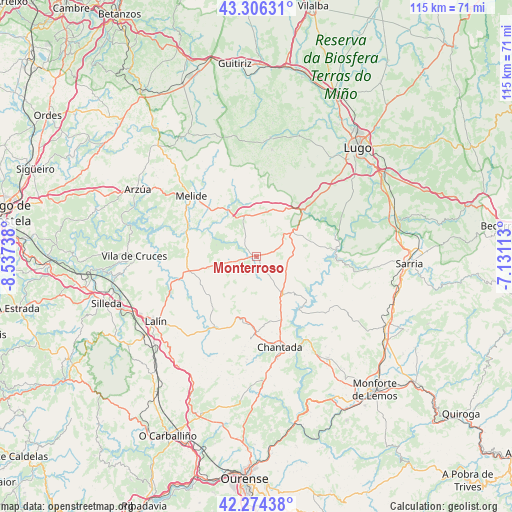
Monterroso GPS coordinates[2]
42° 47' 33" North, 7° 50' 3.3" West
| Map corner | latitude | longitude |
|---|---|---|
| Upper-left | 43.30631°, | -8.53738° |
| Center: | 42.7925°, | -7.83425° |
| Lower-right: | 42.27438°, | -7.13113° |
| Map W x H: | 114.7×114.7 km | = 71.3×71.3mi |
| max Lat: | 43.74134° ⇑7.4% North |
| Monterroso: | 42.7925° |
| min Lat: | ⇓92.6% South 27.64134° |
| min Long | Monterroso | max Long |
| -18.00367° | -7.83425° | 4.2899° |
| W 4%⇐ | ⇒96% E |
Elevation
Elevation of Monterroso is 549 m = 1801 ft, and this is 49 m = 161 ft below average elevation for this country.
| Max E: |
1682 m = 5518 ft | 58.3% |
| Avg. | 598 m = 1962 ft | |
| Monterroso | 549 m = 1801 ft | |
Min E: |
0 m = 0 ft | 41.7% |
See also: Spain elevation on elevation.city.
Geographical zone
Monterroso is located in North temperate zone (between Tropic of Cancer and the Arctic Circle). Distance of this Northern Tropic circle is 2152.2 km =1337.3 mi to South.| Distance of | km | miles | from Monterroso |
|---|---|---|---|
| North Pole | 5249 | 3261.6 | to North |
| Arctic Circle | 2643.1 | 1642.3 | to North |
| Tropic Cancer | 2152.2 | 1337.3 | to South |
| Equator | 4758.1 | 2956.5 | to South |


Nearby cities:
15 places around Monterroso: (largest is in red/bold)
• Arzúa
30.1 km =18.7 mi,  301°
301°
• Carballedo
30.1 km =18.7 mi,  179°
179°
• Castro
20.7 km =12.9 mi,  97°
97°
• Chantada
21.1 km =13.1 mi,  165°
165°
• Dozón
27.6 km =17.1 mi,  212°
212°
• Friol
26.8 km =16.7 mi,  6°
6°
• Guntín
15.6 km =9.7 mi,  47°
47°
• Lalín
27.1 km =16.8 mi,  237°
237°
• Melide
20 km =12.4 mi,  312°
312°
• Ourol
19.9 km =12.4 mi,  64°
64°
• Paradela
22 km =13.7 mi, 97°
• Portomarín
17.8 km =11.1 mi,  85°
85°
• Rodeiro
18.5 km =11.5 mi, 212°
• Santiso
20.1 km =12.5 mi, 296°
• Taboada
10.4 km =6.5 mi, 174°
Sources, notices
• [Note1] Compared only with cities in Spain existing in our database
• [Src1] Map data: © OpenStreetMap contributors (CC-BY-SA)
• [Src2] Other city data from geonames.org with taken over terms of usage.
• [Src3] Geographical zone / Annual Mean Temperature by Robert A. Rohde @ Wikipedia
