Portomarín geodata
Portomarín (Galicia) is a seat of a third-order administrative division; located in Spain in Europe/Madrid (GMT+2) time zone. In our database, there are 6762 cities with bigger population. Compared to other cities in Spain, 92.7% of cities are located further ↓South; 95.6% of cities are located further →East and 71% of cities have higher elevation than Portomarín. Note1


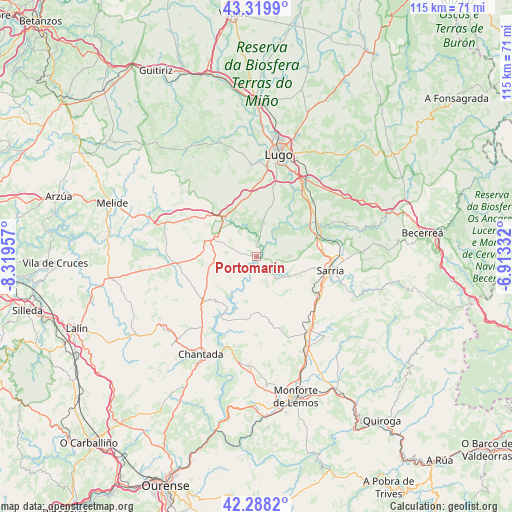
Portomarín GPS coordinates[2]
42° 48' 22.32" North, 7° 36' 59.184" West
| Map corner | latitude | longitude |
|---|---|---|
| Upper-left | 43.3199°, | -8.31957° |
| Center: | 42.8062°, | -7.61644° |
| Lower-right: | 42.2882°, | -6.91332° |
| Map W x H: | 114.7×114.7 km | = 71.3×71.3mi |
| max Lat: | 43.74134° ⇑7.3% North |
| Portomarín: | 42.8062° |
| min Lat: | ⇓92.7% South 27.64134° |
| min Long | Portomarín | max Long |
| -18.00367° | -7.61644° | 4.2899° |
| W 4.4%⇐ | ⇒95.6% E |
Elevation
Elevation of Portomarín is 367 m = 1204 ft, and this is 231 m = 758 ft below average elevation for this country.
| Max E: |
1682 m = 5518 ft | 71% |
| Avg. | 598 m = 1962 ft | |
| Portomarín | 367 m = 1204 ft | |
Min E: |
0 m = 0 ft | 29% |
See also: Spain elevation on elevation.city.
Geographical zone
Portomarín is located in North temperate zone (between Tropic of Cancer and the Arctic Circle). Distance of this Northern Tropic circle is 2153.7 km =1338.2 mi to South.| Distance of | km | miles | from Portomarín |
|---|---|---|---|
| North Pole | 5247.5 | 3260.6 | to North |
| Arctic Circle | 2641.6 | 1641.4 | to North |
| Tropic Cancer | 2153.7 | 1338.2 | to South |
| Equator | 4759.6 | 2957.5 | to South |


Nearby cities:
15 places around Portomarín: (largest is in red/bold)
• Bóveda
23.2 km =14.4 mi,  150°
150°
• Castro
5.2 km =3.2 mi, 148°
• Chantada
25.3 km =15.7 mi,  209°
209°
• Corgo
21.5 km =13.4 mi,  44°
44°
• Friol
29 km =18 mi,  329°
329°
• Guntín
10.9 km =6.8 mi, 325°
• Lugo
23.2 km =14.4 mi,  12°
12°
• Láncara
23.7 km =14.7 mi,  74°
74°
• Monterroso
17.8 km =11.1 mi,  265°
265°
• O Incio
29 km =18 mi,  131°
131°
• Ourol
7.1 km =4.4 mi,  1°
1°
• Paradela
6 km =3.7 mi,  137°
137°
• Samos
25.2 km =15.7 mi,  109°
109°
• Sarria
16.7 km =10.4 mi,  99°
99°
• Taboada
20.7 km =12.9 mi,  234°
234°
Sources, notices
• [Note1] Compared only with cities in Spain existing in our database
• [Src1] Map data: © OpenStreetMap contributors (CC-BY-SA)
• [Src2] Other city data from geonames.org with taken over terms of usage.
• [Src3] Geographical zone / Annual Mean Temperature by Robert A. Rohde @ Wikipedia
