Taboada geodata
Taboada (Galicia) is a populated place; located in Spain in Europe/Madrid (GMT+2) time zone. With population of 3,818 people, there are 1511 cities with bigger population in this country. Compared to other cities in Spain, 91.5% of cities are located further ↓South; 95.9% of cities are located further →East and 53% of cities have higher elevation than Taboada. Note1


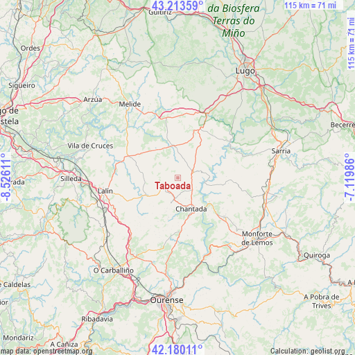
Taboada GPS coordinates[2]
42° 41' 56.4" North, 7° 49' 22.728" West
| Map corner | latitude | longitude |
|---|---|---|
| Upper-left | 43.21359°, | -8.52611° |
| Center: | 42.699°, | -7.82298° |
| Lower-right: | 42.18011°, | -7.11986° |
| Map W x H: | 114.9×114.9 km | = 71.4×71.4mi |
| max Lat: | 43.74134° ⇑8.5% North |
| Taboada: | 42.699° |
| min Lat: | ⇓91.5% South 27.64134° |
| min Long | Taboada | max Long |
| -18.00367° | -7.82298° | 4.2899° |
| W 4.1%⇐ | ⇒95.9% E |
Elevation
Elevation of Taboada is 623 m = 2044 ft, and this is 25 m = 82 ft above average elevation for this country.
| Max E: |
1682 m = 5518 ft | 53% |
| Taboada | 623 m 2044 ft | |
| Avg. | 598 m = 1962 ft | |
Min E: |
0 m = 0 ft | 47% |
See also: Spain elevation on elevation.city.
Geographical zone
Taboada is located in North temperate zone (between Tropic of Cancer and the Arctic Circle). Distance of this Northern Tropic circle is 2141.8 km =1330.9 mi to South.| Distance of | km | miles | from Taboada |
|---|---|---|---|
| North Pole | 5259.4 | 3268 | to North |
| Arctic Circle | 2653.5 | 1648.8 | to North |
| Tropic Cancer | 2141.8 | 1330.9 | to South |
| Equator | 4747.7 | 2950.1 | to South |


Nearby cities:
15 places around Taboada: (largest is in red/bold)
• Carballedo
19.7 km =12.2 mi,  181°
181°
• Castro
21 km =13 mi,  68°
68°
• Chantada
10.9 km =6.8 mi,  157°
157°
• Dozón
20.4 km =12.7 mi,  230°
230°
• Guntín
23.5 km =14.6 mi,  26°
26°
• Lalín
24.1 km =15 mi,  259°
259°
• Monterroso
10.4 km =6.5 mi,  354°
354°
• Ourol
25.5 km =15.8 mi,  41°
41°
• Pantón
27.3 km =17 mi,  138°
138°
• Paradela
22.2 km =13.8 mi, 70°
• Piñor
26.4 km =16.4 mi,  213°
213°
• Portomarín
20.7 km =12.9 mi,  54°
54°
• Rodeiro
12 km =7.5 mi,  244°
244°
• Santiso
27.1 km =16.8 mi,  315°
315°
• Vilamarín
26.6 km =16.5 mi,  192°
192°
Sources, notices
• [Note1] Compared only with cities in Spain existing in our database
• [Src1] Map data: © OpenStreetMap contributors (CC-BY-SA)
• [Src2] Other city data from geonames.org with taken over terms of usage.
• [Src3] Geographical zone / Annual Mean Temperature by Robert A. Rohde @ Wikipedia
