Guntín geodata
Guntín (Galicia) is a seat of a third-order administrative division; located in Spain in Europe/Madrid (GMT+2) time zone. In our database, there are 6762 cities with bigger population. Compared to other cities in Spain, 93.5% of cities are located further ↓South; 95.7% of cities are located further →East and 66.1% of cities have higher elevation than Guntín. Note1


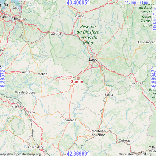
Guntín GPS coordinates[2]
42° 53' 13.272" North, 7° 41' 33.324" West
| Map corner | latitude | longitude |
|---|---|---|
| Upper-left | 43.40005°, | -8.39572° |
| Center: | 42.88702°, | -7.69259° |
| Lower-right: | 42.36969°, | -6.98947° |
| Map W x H: | 114.6×114.6 km | = 71.2×71.2mi |
| max Lat: | 43.74134° ⇑6.5% North |
| Guntín: | 42.88702° |
| min Lat: | ⇓93.5% South 27.64134° |
| min Long | Guntín | max Long |
| -18.00367° | -7.69259° | 4.2899° |
| W 4.3%⇐ | ⇒95.7% E |
Elevation
Elevation of Guntín is 445 m = 1460 ft, and this is 153 m = 502 ft below average elevation for this country.
| Max E: |
1682 m = 5518 ft | 66.1% |
| Avg. | 598 m = 1962 ft | |
| Guntín | 445 m = 1460 ft | |
Min E: |
0 m = 0 ft | 33.9% |
See also: Spain elevation on elevation.city.
Geographical zone
Guntín is located in North temperate zone (between Tropic of Cancer and the Arctic Circle). Distance of this Northern Tropic circle is 2162.7 km =1343.8 mi to South.| Distance of | km | miles | from Guntín |
|---|---|---|---|
| North Pole | 5238.5 | 3255.1 | to North |
| Arctic Circle | 2632.6 | 1635.8 | to North |
| Tropic Cancer | 2162.7 | 1343.8 | to South |
| Equator | 4768.6 | 2963.1 | to South |


Nearby cities:
15 places around Guntín: (largest is in red/bold)
• Begonte
29.4 km =18.3 mi,  0°
0°
• Castro
16.1 km =10 mi,  146°
146°
• Corgo
22.2 km =13.8 mi,  73°
73°
• Friol
18.2 km =11.3 mi,  332°
332°
• Lugo
17.6 km =10.9 mi,  39°
39°
• Láncara
29.1 km =18.1 mi,  94°
94°
• Melide
26.4 km =16.4 mi,  276°
276°
• Monterroso
15.6 km =9.7 mi,  227°
227°
• Ourol
6.6 km =4.1 mi,  106°
106°
• Outeiro de Rei
24.7 km =15.3 mi,  14°
14°
• Paradela
16.9 km =10.5 mi,  142°
142°
• Portomarín
10.9 km =6.8 mi, 145°
• Rábade
26.3 km =16.3 mi, 13°
• Sarria
25.5 km =15.8 mi,  117°
117°
• Taboada
23.5 km =14.6 mi,  206°
206°
Sources, notices
• [Note1] Compared only with cities in Spain existing in our database
• [Src1] Map data: © OpenStreetMap contributors (CC-BY-SA)
• [Src2] Other city data from geonames.org with taken over terms of usage.
• [Src3] Geographical zone / Annual Mean Temperature by Robert A. Rohde @ Wikipedia
