Monreal geodata
Monreal (Navarre) is a seat of a third-order administrative division; located in Spain in Europe/Madrid (GMT+2) time zone. With population of 369 people, there are 4239 cities with bigger population in this country. Compared to other cities in Spain, 91.5% of cities are located further ↓South; 72.8% of cities are located further ←West and 59.2% of cities have higher elevation than Monreal. Note1


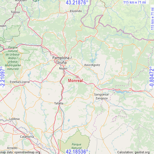
Monreal GPS coordinates[2]
42° 42' 15.156" North, 1° 30' 28.26" West
| Map corner | latitude | longitude |
|---|---|---|
| Upper-left | 43.21876°, | -2.21097° |
| Center: | 42.70421°, | -1.50785° |
| Lower-right: | 42.18536°, | -0.80472° |
| Map W x H: | 114.9×114.9 km | = 71.4×71.4mi |
| max Lat: | 43.74134° ⇑8.5% North |
| Monreal: | 42.70421° |
| min Lat: | ⇓91.5% South 27.64134° |
| min Long | Monreal | max Long |
| -18.00367° | -1.50785° | 4.2899° |
| W 72.8%⇐ | ⇒27.2% E |
Elevation
Elevation of Monreal is 538 m = 1765 ft, and this is 60 m = 197 ft below average elevation for this country.
| Max E: |
1682 m = 5518 ft | 59.2% |
| Avg. | 598 m = 1962 ft | |
| Monreal | 538 m = 1765 ft | |
Min E: |
0 m = 0 ft | 40.8% |
See also: Spain elevation on elevation.city.
Geographical zone
Monreal is located in North temperate zone (between Tropic of Cancer and the Arctic Circle). Distance of this Northern Tropic circle is 2142.3 km =1331.2 mi to South.| Distance of | km | miles | from Monreal |
|---|---|---|---|
| North Pole | 5258.8 | 3267.7 | to North |
| Arctic Circle | 2652.9 | 1648.4 | to North |
| Tropic Cancer | 2142.3 | 1331.2 | to South |
| Equator | 4748.3 | 2950.5 | to South |


Nearby cities:
15 places around Monreal: (largest is in red/bold)
• Aoiz
14.3 km =8.9 mi,  50°
50°
• Barásoain
15.9 km =9.9 mi,  225°
225°
• Beriáin
11.6 km =7.2 mi,  286°
286°
• Burlata
16.2 km =10.1 mi,  326°
326°
• Elorz
5.4 km =3.4 mi,  305°
305°
• Eslava
16 km =9.9 mi,  165°
165°
• Garínoain
16.1 km =10 mi,  224°
224°
• Huarte-Uharte
15.6 km =9.7 mi, 334°
• Leache
13.6 km =8.5 mi,  142°
142°
• Lerga
15.2 km =9.4 mi,  177°
177°
• Lizoáin
11 km =6.8 mi,  17°
17°
• Olóriz
11.5 km =7.1 mi, 228°
• Orísoain
13.9 km =8.6 mi,  214°
214°
• Sarriguren
14.2 km =8.8 mi, 328°
• Unzué
11.2 km =7 mi,  239°
239°
Sources, notices
• [Note1] Compared only with cities in Spain existing in our database
• [Src1] Map data: © OpenStreetMap contributors (CC-BY-SA)
• [Src2] Other city data from geonames.org with taken over terms of usage.
• [Src3] Geographical zone / Annual Mean Temperature by Robert A. Rohde @ Wikipedia
