Rodeiro geodata
Rodeiro (Galicia) is a seat of a third-order administrative division; located in Spain in Europe/Madrid (GMT+2) time zone. With population of 3,376 people, there are 1612 cities with bigger population in this country. Compared to other cities in Spain, 90.7% of cities are located further ↓South; 96.2% of cities are located further →East and 50.1% of cities have higher elevation than Rodeiro. Note1


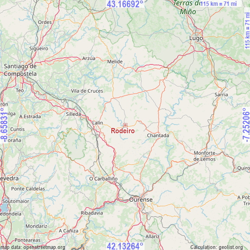
Rodeiro GPS coordinates[2]
42° 39' 6.948" North, 7° 57' 18.684" West
| Map corner | latitude | longitude |
|---|---|---|
| Upper-left | 43.16692°, | -8.65831° |
| Center: | 42.65193°, | -7.95519° |
| Lower-right: | 42.13264°, | -7.25206° |
| Map W x H: | 115×115 km | = 71.5×71.5mi |
| max Lat: | 43.74134° ⇑9.3% North |
| Rodeiro: | 42.65193° |
| min Lat: | ⇓90.7% South 27.64134° |
| min Long | Rodeiro | max Long |
| -18.00367° | -7.95519° | 4.2899° |
| W 3.8%⇐ | ⇒96.2% E |
Elevation
Elevation of Rodeiro is 656 m = 2152 ft, and this is 58 m = 190 ft above average elevation for this country.
| Max E: |
1682 m = 5518 ft | 50.1% |
| Rodeiro | 656 m 2152 ft | |
| Avg. | 598 m = 1962 ft | |
Min E: |
0 m = 0 ft | 49.9% |
See also: Spain elevation on elevation.city.
Geographical zone
Rodeiro is located in North temperate zone (between Tropic of Cancer and the Arctic Circle). Distance of this Northern Tropic circle is 2136.5 km =1327.6 mi to South.| Distance of | km | miles | from Rodeiro |
|---|---|---|---|
| North Pole | 5264.6 | 3271.3 | to North |
| Arctic Circle | 2658.7 | 1652 | to North |
| Tropic Cancer | 2136.5 | 1327.6 | to South |
| Equator | 4742.5 | 2946.9 | to South |


Nearby cities:
15 places around Rodeiro: (largest is in red/bold)
• Amoeiro
26.2 km =16.3 mi,  179°
179°
• Boborás
28.8 km =17.9 mi,  212°
212°
• Carballedo
17.8 km =11.1 mi,  144°
144°
• Cea
19.9 km =12.4 mi,  187°
187°
• Chantada
15.8 km =9.8 mi,  107°
107°
• Dozón
9.1 km =5.7 mi, 213°
• Lalín
12.9 km =8 mi,  274°
274°
• Maside
27.5 km =17.1 mi, 192°
• Monterroso
18.5 km =11.5 mi,  32°
32°
• O Carballiño
26.5 km =16.5 mi,  202°
202°
• Piñor
17.2 km =10.7 mi, 192°
• Santiso
26 km =16.2 mi,  341°
341°
• Silleda
24.3 km =15.1 mi,  281°
281°
• Taboada
12 km =7.5 mi,  64°
64°
• Vilamarín
21.4 km =13.3 mi,  165°
165°
Sources, notices
• [Note1] Compared only with cities in Spain existing in our database
• [Src1] Map data: © OpenStreetMap contributors (CC-BY-SA)
• [Src2] Other city data from geonames.org with taken over terms of usage.
• [Src3] Geographical zone / Annual Mean Temperature by Robert A. Rohde @ Wikipedia
