Lalín geodata
Lalín (Galicia) is a populated place; located in Spain in Europe/Madrid (GMT+2) time zone. With population of 21,254 people, there are 452 cities with bigger population in this country. Compared to other cities in Spain, 90.9% of cities are located further ↓South; 96.6% of cities are located further →East and 58% of cities have higher elevation than Lalín. Note1


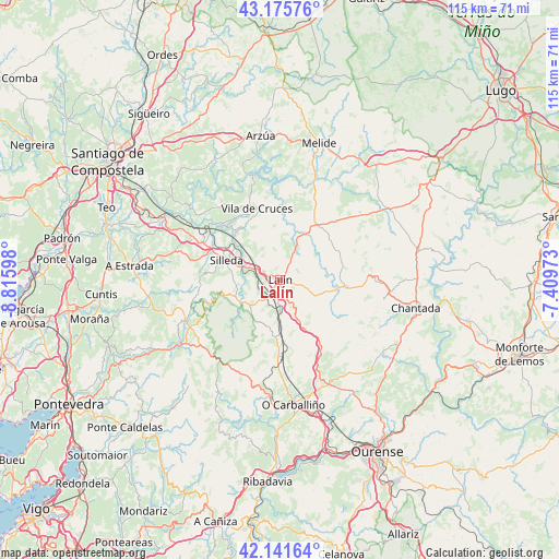
Lalín GPS coordinates[2]
42° 39' 39.06" North, 8° 6' 46.26" West
| Map corner | latitude | longitude |
|---|---|---|
| Upper-left | 43.17576°, | -8.81598° |
| Center: | 42.66085°, | -8.11285° |
| Lower-right: | 42.14164°, | -7.40973° |
| Map W x H: | 115×115 km | = 71.5×71.5mi |
| max Lat: | 43.74134° ⇑9.1% North |
| Lalín: | 42.66085° |
| min Lat: | ⇓90.9% South 27.64134° |
| min Long | Lalín | max Long |
| -18.00367° | -8.11285° | 4.2899° |
| W 3.4%⇐ | ⇒96.6% E |
Elevation
Elevation of Lalín is 552 m = 1811 ft, and this is 46 m = 151 ft below average elevation for this country.
| Max E: |
1682 m = 5518 ft | 58% |
| Avg. | 598 m = 1962 ft | |
| Lalín | 552 m = 1811 ft | |
Min E: |
0 m = 0 ft | 42% |
See also: Spain elevation on elevation.city.
Geographical zone
Lalín is located in North temperate zone (between Tropic of Cancer and the Arctic Circle). Distance of this Northern Tropic circle is 2137.5 km =1328.2 mi to South.| Distance of | km | miles | from Lalín |
|---|---|---|---|
| North Pole | 5263.6 | 3270.6 | to North |
| Arctic Circle | 2657.7 | 1651.4 | to North |
| Tropic Cancer | 2137.5 | 1328.2 | to South |
| Equator | 4743.4 | 2947.4 | to South |


Nearby cities:
15 places around Lalín: (largest is in red/bold)
• Boborás
25.4 km =15.8 mi,  185°
185°
• Carballedo
27.9 km =17.3 mi,  123°
123°
• Cea
23.1 km =14.4 mi,  153°
153°
• Chantada
28.5 km =17.7 mi,  101°
101°
• Dozón
11.7 km =7.3 mi,  137°
137°
• Forcarei
20.9 km =13 mi,  248°
248°
• Monterroso
27.1 km =16.8 mi,  57°
57°
• O Carballiño
25.6 km =15.9 mi,  173°
173°
• Piñor
20 km =12.4 mi, 152°
• Rodeiro
12.9 km =8 mi,  94°
94°
• Santiso
24.2 km =15 mi,  11°
11°
• Silleda
11.6 km =7.2 mi,  289°
289°
• Taboada
24.1 km =15 mi,  79°
79°
• Touro
28 km =17.4 mi,  325°
325°
• Vilamarín
28.4 km =17.6 mi, 140°
Sources, notices
• [Note1] Compared only with cities in Spain existing in our database
• [Src1] Map data: © OpenStreetMap contributors (CC-BY-SA)
• [Src2] Other city data from geonames.org with taken over terms of usage.
• [Src3] Geographical zone / Annual Mean Temperature by Robert A. Rohde @ Wikipedia
