Jimma geodata
Jimma (Oromiya) is a populated place; located in Ethiopia in Africa/Addis_Ababa (GMT+3) time zone. With population of 128,306 people, there are 8 cities with bigger population in this country. Compared to other cities in Ethiopia, 69.2% of cities are located further ↑North; 84.1% of cities are located further →East and 68.2% of cities have higher elevation than Jimma. Note1


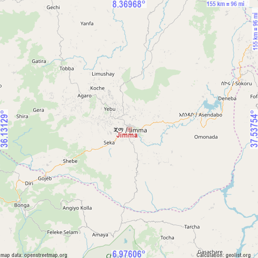
Jimma GPS coordinates[2]
7° 40' 24.384" North, 36° 50' 3.876" East
| Map corner | latitude | longitude |
|---|---|---|
| Upper-left | 8.36968°, | 36.13129° |
| Center: | 7.67344°, | 36.83441° |
| Lower-right: | 6.97606°, | 37.53754° |
| Map W x H: | 155×155 km | = 96.3×96.3mi |
| max Lat: | 14.277° ⇑69.2% North |
| Jimma: | 7.67344° |
| min Lat: | ⇓30.8% South 4.05° |
| min Long | Jimma | max Long |
| 34.53333° | 36.83441° | 42.8° |
| W 15.9%⇐ | ⇒84.1% E |
Elevation
Elevation of Jimma is 1719 m = 5640 ft, and this is 176.6 m = 579 ft below average elevation for this country.
| Max E: |
2854 m = 9364 ft | 68.2% |
| Avg. | 1895.6 m = 6219 ft | |
| Jimma | 1719 m = 5640 ft | |
Min E: |
367 m = 1204 ft | 31.8% |
See also: Jimma elevation on elevation.city.
Geographical zone
Jimma is located in North Torrid zone (between Equator and Tropic of Cancer). Distance of Equator is 853.2 km =530.2 mi to South.| Distance of | km | miles | from Jimma |
|---|---|---|---|
| North Pole | 9153.9 | 5688 | to North |
| Arctic Circle | 6548 | 4068.7 | to North |
| Tropic Cancer | 1752.7 | 1089.1 | to North |
| Equator | 853.2 | 530.2 | to South |


Nearby cities:
15 places around Jimma: (largest is in red/bold)
• Bedelē
101.9 km =63.3 mi,  328°
328°
• Bodītī
138.3 km =85.9 mi,  124°
124°
• Bonga
79.2 km =49.2 mi,  236°
236°
• Felege Neway
152.8 km =94.9 mi,  177°
177°
• Gorē
152.8 km =94.9 mi,  290°
290°
• Gēdo
164 km =101.9 mi,  24°
24°
• Hosa’ina
113.2 km =70.3 mi,  96°
96°
• K’olīto
143.3 km =89 mi,  106°
106°
• Metu
154.4 km =95.9 mi,  296°
296°
• Mīzan Teferī
156.5 km =97.2 mi, 241°
• Sodo
136.5 km =84.8 mi,  131°
131°
• Tippi
161.5 km =100.4 mi,  250°
250°
• Waliso
157 km =97.6 mi,  52°
52°
• Āgaro
28.3 km =17.6 mi,  314°
314°
• Āreka
116.9 km =72.6 mi, 125°
Sources, notices
• [Note1] Compared only with cities in Ethiopia existing in our database
• [Src1] Map data: © OpenStreetMap contributors (CC-BY-SA)
• [Src2] Other city data from geonames.org with taken over terms of usage.
• [Src3] Geographical zone / Annual Mean Temperature by Robert A. Rohde @ Wikipedia
