K’olīto geodata
K’olīto (SNNPR) is a populated place; located in Ethiopia in Africa/Addis_Ababa (GMT+3) time zone. With population of 25,614 people, there are 49 cities with bigger population in this country. Compared to other cities in Ethiopia, 71% of cities are located further ↑North; 61.7% of cities are located further →East and 61.7% of cities have higher elevation than K’olīto. Note1


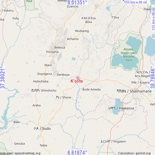
K’olīto GPS coordinates[2]
7° 19' 0.012" North, 38° 4' 59.988" East
| Map corner | latitude | longitude |
|---|---|---|
| Upper-left | 8.01351°, | 37.38021° |
| Center: | 7.31667°, | 38.08333° |
| Lower-right: | 6.61874°, | 38.78646° |
| Map W x H: | 155.1×155.1 km | = 96.4×96.4mi |
| max Lat: | 14.277° ⇑71% North |
| K’olīto: | 7.31667° |
| min Lat: | ⇓29% South 4.05° |
| min Long | K’olīto | max Long |
| 34.53333° | 38.08333° | 42.8° |
| W 38.3%⇐ | ⇒61.7% E |
Elevation
Elevation of K’olīto is 1781 m = 5843 ft, and this is 114.6 m = 376 ft below average elevation for this country.
| Max E: |
2854 m = 9364 ft | 61.7% |
| Avg. | 1895.6 m = 6219 ft | |
| K’olīto | 1781 m = 5843 ft | |
Min E: |
367 m = 1204 ft | 38.3% |
See also: Ethiopia elevation on elevation.city.
Geographical zone
K’olīto is located in North Torrid zone (between Equator and Tropic of Cancer). Distance of Equator is 813.5 km =505.5 mi to South.| Distance of | km | miles | from K’olīto |
|---|---|---|---|
| North Pole | 9193.5 | 5712.6 | to North |
| Arctic Circle | 6587.6 | 4093.3 | to North |
| Tropic Cancer | 1792.4 | 1113.7 | to North |
| Equator | 813.5 | 505.5 | to South |


Nearby cities:
15 places around K’olīto: (largest is in red/bold)
• Bodītī
45.7 km =28.4 mi,  211°
211°
• Butajīra
94.3 km =58.6 mi,  19°
19°
• Dīla
103.3 km =64.2 mi,  165°
165°
• Hawassa
51.8 km =32.2 mi,  123°
123°
• Hosa’ina
36.2 km =22.5 mi,  315°
315°
• Hāgere Selam
104.3 km =64.8 mi,  152°
152°
• Kofelē
82.1 km =51 mi,  109°
109°
• Leku
63.4 km =39.4 mi,  141°
141°
• Shashemenē
58.4 km =36.3 mi,  102°
102°
• Sodo
62 km =38.5 mi, 214°
• Wendo
87.8 km =54.6 mi,  155°
155°
• Yirga ‘Alem
73 km =45.4 mi, 149°
• Ziway
97.8 km =60.8 mi,  45°
45°
• Āreka
50.6 km =31.4 mi,  236°
236°
• Āsasa
125.5 km =78 mi, 101°
Sources, notices
• [Note1] Compared only with cities in Ethiopia existing in our database
• [Src1] Map data: © OpenStreetMap contributors (CC-BY-SA)
• [Src2] Other city data from geonames.org with taken over terms of usage.
• [Src3] Geographical zone / Annual Mean Temperature by Robert A. Rohde @ Wikipedia
