Hosa’ina geodata
Hosa’ina (SNNPR) is a populated place; located in Ethiopia in Africa/Addis_Ababa (GMT+3) time zone. With population of 75,963 people, there are 14 cities with bigger population in this country. Compared to other cities in Ethiopia, 70.1% of cities are located further ↑North; 66.4% of cities are located further →East and 73.8% of cities have lower elevation than Hosa’ina. Note1


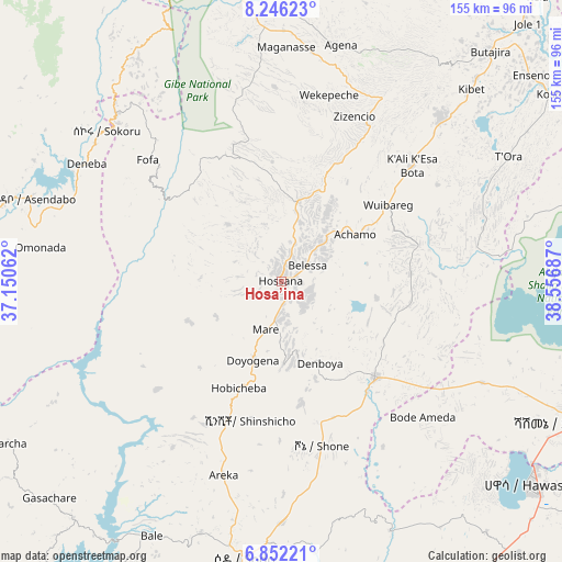
Hosa’ina GPS coordinates[2]
7° 32' 59.208" North, 37° 51' 13.464" East
| Map corner | latitude | longitude |
|---|---|---|
| Upper-left | 8.24623°, | 37.15062° |
| Center: | 7.54978°, | 37.85374° |
| Lower-right: | 6.85221°, | 38.55687° |
| Map W x H: | 155×155 km | = 96.3×96.3mi |
| max Lat: | 14.277° ⇑70.1% North |
| Hosa’ina: | 7.54978° |
| min Lat: | ⇓29.9% South 4.05° |
| min Long | Hosa’ina | max Long |
| 34.53333° | 37.85374° | 42.8° |
| W 33.6%⇐ | ⇒66.4% E |
Elevation
Elevation of Hosa’ina is 2329 m = 7641 ft, and this is 433.4 m = 1422 ft above average elevation for this country.
| Max E: |
2854 m = 9364 ft | 26.2% |
| Hosa’ina | 2329 m 7641 ft | |
| Avg. | 1895.6 m = 6219 ft | |
Min E: |
367 m = 1204 ft | 73.8% |
See also: Hosa’ina elevation on elevation.city.
Geographical zone
Hosa’ina is located in North Torrid zone (between Equator and Tropic of Cancer). Distance of Equator is 839.5 km =521.6 mi to South.| Distance of | km | miles | from Hosa’ina |
|---|---|---|---|
| North Pole | 9167.6 | 5696.5 | to North |
| Arctic Circle | 6561.7 | 4077.3 | to North |
| Tropic Cancer | 1766.5 | 1097.7 | to North |
| Equator | 839.5 | 521.6 | to South |


Nearby cities:
15 places around Hosa’ina: (largest is in red/bold)
• Bodītī
64.9 km =40.3 mi,  178°
178°
• Butajīra
84.6 km =52.6 mi,  41°
41°
• Hawassa
87.5 km =54.4 mi,  128°
128°
• Jimma
113.2 km =70.3 mi,  276°
276°
• Kofelē
115.7 km =71.9 mi,  117°
117°
• K’olīto
36.2 km =22.5 mi,  135°
135°
• Leku
99.5 km =61.8 mi, 139°
• Shashemenē
91 km =56.5 mi, 115°
• Sodo
77.4 km =48.1 mi,  187°
187°
• Tulu Bolo
130.5 km =81.1 mi,  17°
17°
• Waliso
110.1 km =68.4 mi,  6°
6°
• Wendo
122.5 km =76.1 mi,  149°
149°
• Yirga ‘Alem
108.5 km =67.4 mi, 145°
• Ziway
104.2 km =64.7 mi,  65°
65°
• Āreka
56.3 km =35 mi,  197°
197°
Sources, notices
• [Note1] Compared only with cities in Ethiopia existing in our database
• [Src1] Map data: © OpenStreetMap contributors (CC-BY-SA)
• [Src2] Other city data from geonames.org with taken over terms of usage.
• [Src3] Geographical zone / Annual Mean Temperature by Robert A. Rohde @ Wikipedia
