Bedelē geodata
Bedelē (Oromiya) is a populated place; located in Ethiopia in Africa/Addis_Ababa (GMT+3) time zone. With population of 20,293 people, there are 65 cities with bigger population in this country. Compared to other cities in Ethiopia, 59.8% of cities are located further ↑North; 88.8% of cities are located further →East and 57.9% of cities have lower elevation than Bedelē. Note1


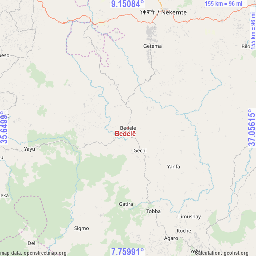
Bedelē GPS coordinates[2]
8° 27' 21.6" North, 36° 21' 10.872" East
| Map corner | latitude | longitude |
|---|---|---|
| Upper-left | 9.15084°, | 35.6499° |
| Center: | 8.456°, | 36.35302° |
| Lower-right: | 7.75991°, | 37.05615° |
| Map W x H: | 154.7×154.7 km | = 96.1×96.1mi |
| max Lat: | 14.277° ⇑59.8% North |
| Bedelē: | 8.456° |
| min Lat: | ⇓40.2% South 4.05° |
| min Long | Bedelē | max Long |
| 34.53333° | 36.35302° | 42.8° |
| W 11.2%⇐ | ⇒88.8% E |
Elevation
Elevation of Bedelē is 2011 m = 6598 ft, and this is 115.4 m = 379 ft above average elevation for this country.
| Max E: |
2854 m = 9364 ft | 42.1% |
| Bedelē | 2011 m 6598 ft | |
| Avg. | 1895.6 m = 6219 ft | |
Min E: |
367 m = 1204 ft | 57.9% |
See also: Ethiopia elevation on elevation.city.
Geographical zone
Bedelē is located in North Torrid zone (between Equator and Tropic of Cancer). Distance of Equator is 940.2 km =584.2 mi to South.| Distance of | km | miles | from Bedelē |
|---|---|---|---|
| North Pole | 9066.8 | 5633.8 | to North |
| Arctic Circle | 6461 | 4014.7 | to North |
| Tropic Cancer | 1665.7 | 1035 | to North |
| Equator | 940.2 | 584.2 | to South |


Nearby cities:
15 places around Bedelē: (largest is in red/bold)
• Bonga
131.1 km =81.5 mi,  185°
185°
• Dembī Dolo
171 km =106.3 mi,  272°
272°
• Gimbi
97.7 km =60.7 mi,  324°
324°
• Gorē
96.4 km =59.9 mi,  249°
249°
• Gēdo
135.7 km =84.3 mi,  62°
62°
• Hosa’ina
193.5 km =120.2 mi,  121°
121°
• Hāgere Hiywet
174.7 km =108.6 mi,  70°
70°
• Jimma
101.9 km =63.3 mi,  148°
148°
• Metu
86.4 km =53.7 mi,  258°
258°
• Mīzan Teferī
182.6 km =113.5 mi,  207°
207°
• Nejo
149.2 km =92.7 mi, 321°
• Shambu
148.3 km =92.1 mi,  33°
33°
• Tippi
171.5 km =106.6 mi,  215°
215°
• Waliso
177.5 km =110.3 mi,  87°
87°
• Āgaro
74.9 km =46.5 mi, 154°
Sources, notices
• [Note1] Compared only with cities in Ethiopia existing in our database
• [Src1] Map data: © OpenStreetMap contributors (CC-BY-SA)
• [Src2] Other city data from geonames.org with taken over terms of usage.
• [Src3] Geographical zone / Annual Mean Temperature by Robert A. Rohde @ Wikipedia
