Bodītī geodata
Bodītī (SNNPR) is a populated place; located in Ethiopia in Africa/Addis_Ababa (GMT+3) time zone. With population of 32,997 people, there are 33 cities with bigger population in this country. Compared to other cities in Ethiopia, 82.2% of cities are located further ↑North; 65.4% of cities are located further →East and 57% of cities have lower elevation than Bodītī. Note1


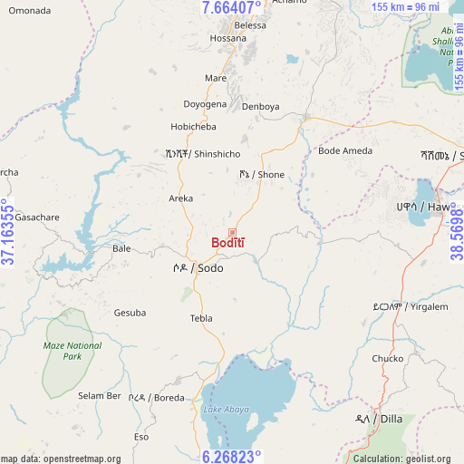
Bodītī GPS coordinates[2]
6° 58' 0.012" North, 37° 52' 0.012" East
| Map corner | latitude | longitude |
|---|---|---|
| Upper-left | 7.66407°, | 37.16355° |
| Center: | 6.96667°, | 37.86667° |
| Lower-right: | 6.26823°, | 38.5698° |
| Map W x H: | 155.2×155.2 km | = 96.4×96.4mi |
| max Lat: | 14.277° ⇑82.2% North |
| Bodītī: | 6.96667° |
| min Lat: | ⇓17.8% South 4.05° |
| min Long | Bodītī | max Long |
| 34.53333° | 37.86667° | 42.8° |
| W 34.6%⇐ | ⇒65.4% E |
Elevation
Elevation of Bodītī is 1998 m = 6555 ft, and this is 102.4 m = 336 ft above average elevation for this country.
| Max E: |
2854 m = 9364 ft | 43% |
| Bodītī | 1998 m 6555 ft | |
| Avg. | 1895.6 m = 6219 ft | |
Min E: |
367 m = 1204 ft | 57% |
See also: Ethiopia elevation on elevation.city.
Geographical zone
Bodītī is located in North Torrid zone (between Equator and Tropic of Cancer). Distance of Equator is 774.6 km =481.3 mi to South.| Distance of | km | miles | from Bodītī |
|---|---|---|---|
| North Pole | 9232.4 | 5736.7 | to North |
| Arctic Circle | 6626.6 | 4117.6 | to North |
| Tropic Cancer | 1831.3 | 1137.9 | to North |
| Equator | 774.6 | 481.3 | to South |


Nearby cities:
15 places around Bodītī: (largest is in red/bold)
• Arba Minch
109.5 km =68 mi,  198°
198°
• Dīla
78.8 km =49 mi,  140°
140°
• Felege Neway
131.5 km =81.7 mi,  235°
235°
• Hawassa
68.1 km =42.3 mi,  81°
81°
• Hosa’ina
64.9 km =40.3 mi,  358°
358°
• Hāgere Selam
89.7 km =55.7 mi,  126°
126°
• Jimma
138.3 km =85.9 mi,  304°
304°
• Kofelē
101.8 km =63.3 mi, 83°
• K’olīto
45.7 km =28.4 mi,  31°
31°
• Leku
64.6 km =40.1 mi,  99°
99°
• Shashemenē
85 km =52.8 mi,  72°
72°
• Sodo
16.6 km =10.3 mi,  224°
224°
• Wendo
73.1 km =45.4 mi,  123°
123°
• Yirga ‘Alem
65.3 km =40.6 mi,  111°
111°
• Āreka
21.5 km =13.4 mi, 301°
Sources, notices
• [Note1] Compared only with cities in Ethiopia existing in our database
• [Src1] Map data: © OpenStreetMap contributors (CC-BY-SA)
• [Src2] Other city data from geonames.org with taken over terms of usage.
• [Src3] Geographical zone / Annual Mean Temperature by Robert A. Rohde @ Wikipedia
