Tuupovaara geodata
Tuupovaara (North Karelia) is a populated place; located in Finland in Europe/Helsinki (GMT+3) time zone. With population of 2,059 people, there are 352 cities with bigger population in this country. Compared to other cities in Finland, 61.1% of cities are located further ↓South; 99.8% of cities are located further ←West and 88.2% of cities have lower elevation than Tuupovaara. Note1


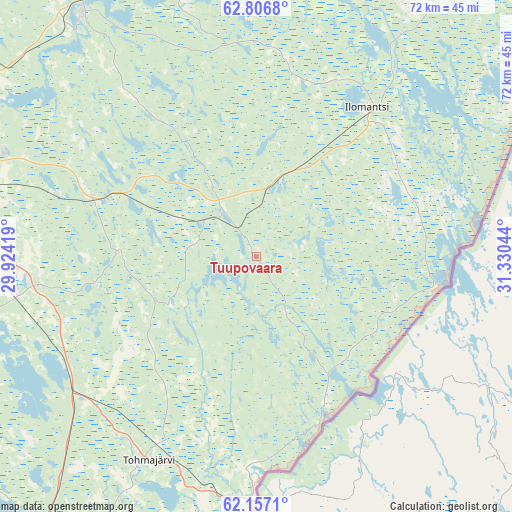
Tuupovaara GPS coordinates[2]
62° 29' 1.392" North, 30° 37' 38.316" East
| Map corner | latitude | longitude |
|---|---|---|
| Upper-left | 62.8068°, | 29.92419° |
| Center: | 62.48372°, | 30.62731° |
| Lower-right: | 62.1571°, | 31.33044° |
| Map W x H: | 72.2×72.2 km | = 44.9×44.9mi |
| max Lat: | 69.90864° ⇑38.9% North |
| Tuupovaara: | 62.48372° |
| min Lat: | ⇓61.1% South 59.83333° |
| min Long | Tuupovaara | max Long |
| 21.2° | 30.62731° | 30.93276° |
| W 99.8%⇐ | ⇒0.2% E |
Elevation
Elevation of Tuupovaara is 137 m = 449 ft, and this is 59.9 m = 197 ft above average elevation for this country.
| Max E: |
299 m = 981 ft | 11.8% |
| Tuupovaara | 137 m 449 ft | |
| Avg. | 77.1 m = 253 ft | |
Min E: |
1 m = 3 ft | 88.2% |
See also: Finland elevation on elevation.city.
Geographical zone
Tuupovaara is located in North temperate zone (between Tropic of Cancer and the Arctic Circle). Distance of this North polar circle is 453.6 km =281.9 mi to North.| Distance of | km | miles | from Tuupovaara |
|---|---|---|---|
| North Pole | 3059.5 | 1901.1 | to North |
| Arctic Circle | 453.6 | 281.9 | to North |
| Tropic Cancer | 4341.6 | 2697.7 | to South |
| Equator | 6947.5 | 4317 | to South |


Nearby cities:
15 places around Tuupovaara: (largest is in red/bold)
• Eno
43.1 km =26.8 mi,  325°
325°
• Ilomantsi
26.1 km =16.2 mi,  36°
36°
• Joensuu
46.2 km =28.7 mi,  286°
286°
• Kesälahti
77.1 km =47.9 mi,  212°
212°
• Kiihtelysvaara
19.4 km =12.1 mi,  273°
273°
• Kitee
49.3 km =30.6 mi, 210°
• Kontiolahti
50.4 km =31.3 mi,  307°
307°
• Liperi
64.9 km =40.3 mi, 274°
• Outokumpu
86.8 km =53.9 mi, 288°
• Polvijärvi
76.2 km =47.3 mi,  302°
302°
• Pyhäselkä
34.4 km =21.4 mi,  260°
260°
• Rääkkylä
55.3 km =34.4 mi,  250°
250°
• Savonranta
80.9 km =50.3 mi, 245°
• Tohmajärvi
35.7 km =22.2 mi,  200°
200°
• Uukuniemi
83.9 km =52.1 mi, 202°
Sources, notices
• [Note1] Compared only with cities in Finland existing in our database
• [Src1] Map data: © OpenStreetMap contributors (CC-BY-SA)
• [Src2] Other city data from geonames.org with taken over terms of usage.
• [Src3] Geographical zone / Annual Mean Temperature by Robert A. Rohde @ Wikipedia
