Rääkkylä geodata
Rääkkylä (North Karelia) is a seat of a third-order administrative division; located in Finland in Europe/Helsinki (GMT+3) time zone. With population of 2,855 people, there are 306 cities with bigger population in this country. Compared to other cities in Finland, 58.8% of cities are located further ↓South; 97.2% of cities are located further ←West and 60% of cities have lower elevation than Rääkkylä. Note1


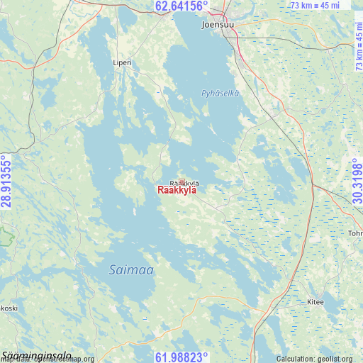
Rääkkylä GPS coordinates[2]
62° 19' 0.012" North, 29° 37' 0.012" East
| Map corner | latitude | longitude |
|---|---|---|
| Upper-left | 62.64156°, | 28.91355° |
| Center: | 62.31667°, | 29.61667° |
| Lower-right: | 61.98823°, | 30.3198° |
| Map W x H: | 72.6×72.6 km | = 45.1×45.1mi |
| max Lat: | 69.90864° ⇑41.2% North |
| Rääkkylä: | 62.31667° |
| min Lat: | ⇓58.8% South 59.83333° |
| min Long | Rääkkylä | max Long |
| 21.2° | 29.61667° | 30.93276° |
| W 97.2%⇐ | ⇒2.8% E |
Elevation
Elevation of Rääkkylä is 95 m = 312 ft, and this is 17.9 m = 59 ft above average elevation for this country.
| Max E: |
299 m = 981 ft | 40% |
| Rääkkylä | 95 m 312 ft | |
| Avg. | 77.1 m = 253 ft | |
Min E: |
1 m = 3 ft | 60% |
See also: Finland elevation on elevation.city.
Geographical zone
Rääkkylä is located in North temperate zone (between Tropic of Cancer and the Arctic Circle). Distance of this North polar circle is 472.2 km =293.4 mi to North.| Distance of | km | miles | from Rääkkylä |
|---|---|---|---|
| North Pole | 3078.1 | 1912.6 | to North |
| Arctic Circle | 472.2 | 293.4 | to North |
| Tropic Cancer | 4323 | 2686.2 | to South |
| Equator | 6929 | 4305.5 | to South |


Nearby cities:
15 places around Rääkkylä: (largest is in red/bold)
• Enonkoski
43.9 km =27.3 mi,  233°
233°
• Heinävesi
54 km =33.6 mi,  283°
283°
• Joensuu
32.5 km =20.2 mi,  13°
13°
• Kerimäki
48.4 km =30.1 mi,  201°
201°
• Kesälahti
48 km =29.8 mi,  166°
166°
• Kiihtelysvaara
38.2 km =23.7 mi,  58°
58°
• Kitee
36.7 km =22.8 mi,  131°
131°
• Kontiolahti
50.7 km =31.5 mi, 13°
• Liperi
27.3 km =17 mi,  331°
331°
• Outokumpu
55 km =34.2 mi, 325°
• Polvijärvi
60.7 km =37.7 mi,  347°
347°
• Pyhäselkä
22.2 km =13.8 mi,  54°
54°
• Savonranta
26.2 km =16.3 mi,  235°
235°
• Tohmajärvi
42.4 km =26.3 mi,  110°
110°
• Tuupovaara
55.3 km =34.4 mi,  70°
70°
Sources, notices
• [Note1] Compared only with cities in Finland existing in our database
• [Src1] Map data: © OpenStreetMap contributors (CC-BY-SA)
• [Src2] Other city data from geonames.org with taken over terms of usage.
• [Src3] Geographical zone / Annual Mean Temperature by Robert A. Rohde @ Wikipedia
