Kiihtelysvaara geodata
Kiihtelysvaara (North Karelia) is a populated place; located in Finland in Europe/Helsinki (GMT+3) time zone. With population of 2,723 people, there are 313 cities with bigger population in this country. Compared to other cities in Finland, 61.5% of cities are located further ↓South; 99.4% of cities are located further ←West and 89.7% of cities have lower elevation than Kiihtelysvaara. Note1


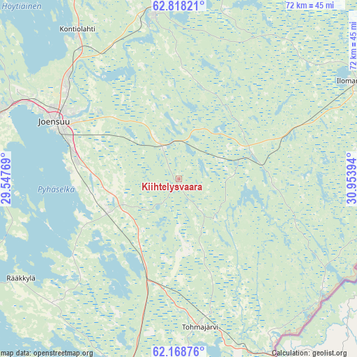
Kiihtelysvaara GPS coordinates[2]
62° 29' 42.9" North, 30° 15' 2.916" East
| Map corner | latitude | longitude |
|---|---|---|
| Upper-left | 62.81821°, | 29.54769° |
| Center: | 62.49525°, | 30.25081° |
| Lower-right: | 62.16876°, | 30.95394° |
| Map W x H: | 72.2×72.2 km | = 44.9×44.9mi |
| max Lat: | 69.90864° ⇑38.5% North |
| Kiihtelysvaara: | 62.49525° |
| min Lat: | ⇓61.5% South 59.83333° |
| min Long | Kiihtelysvaara | max Long |
| 21.2° | 30.25081° | 30.93276° |
| W 99.4%⇐ | ⇒0.59999999999999% E |
Elevation
Elevation of Kiihtelysvaara is 140 m = 459 ft, and this is 62.9 m = 206 ft above average elevation for this country.
| Max E: |
299 m = 981 ft | 10.3% |
| Kiihtelysvaara | 140 m 459 ft | |
| Avg. | 77.1 m = 253 ft | |
Min E: |
1 m = 3 ft | 89.7% |
See also: Finland elevation on elevation.city.
Geographical zone
Kiihtelysvaara is located in North temperate zone (between Tropic of Cancer and the Arctic Circle). Distance of this North polar circle is 452.4 km =281.1 mi to North.| Distance of | km | miles | from Kiihtelysvaara |
|---|---|---|---|
| North Pole | 3058.2 | 1900.3 | to North |
| Arctic Circle | 452.4 | 281.1 | to North |
| Tropic Cancer | 4342.9 | 2698.6 | to South |
| Equator | 6948.8 | 4317.8 | to South |


Nearby cities:
15 places around Kiihtelysvaara: (largest is in red/bold)
• Eno
34.8 km =21.6 mi,  351°
351°
• Ilomantsi
40 km =24.9 mi,  60°
60°
• Joensuu
27.6 km =17.1 mi,  295°
295°
• Kesälahti
69.9 km =43.4 mi,  197°
197°
• Kitee
44.3 km =27.5 mi,  186°
186°
• Kontiolahti
36 km =22.4 mi,  324°
324°
• Liperi
45.6 km =28.3 mi,  275°
275°
• Outokumpu
68.2 km =42.4 mi,  292°
292°
• Polvijärvi
59.9 km =37.2 mi,  311°
311°
• Pyhäselkä
16.1 km =10 mi,  244°
244°
• Rääkkylä
38.2 km =23.7 mi, 238°
• Savonranta
64.4 km =40 mi, 237°
• Tohmajärvi
35.4 km =22 mi,  168°
168°
• Tuupovaara
19.4 km =12.1 mi,  93°
93°
• Uukuniemi
79.8 km =49.6 mi, 189°
Sources, notices
• [Note1] Compared only with cities in Finland existing in our database
• [Src1] Map data: © OpenStreetMap contributors (CC-BY-SA)
• [Src2] Other city data from geonames.org with taken over terms of usage.
• [Src3] Geographical zone / Annual Mean Temperature by Robert A. Rohde @ Wikipedia
