Mehun-sur-Yèvre geodata
Mehun-sur-Yèvre (Centre) is a populated place; located in France in Europe/Paris (GMT+2) time zone. With population of 7,257 people, there are 1344 cities with bigger population in this country. Compared to other cities in France, 53.8% of cities are located further ↑North; 54.3% of cities are located further →East and 52.6% of cities have higher elevation than Mehun-sur-Yèvre. Note1
Administrative division(s):
- Level 1: Centre
- Level 2: Cher
- Level 3: Arrondissement de Vierzon
- Level 4: Mehun-sur-Yèvre


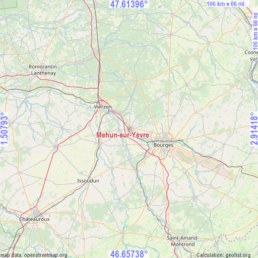
Mehun-sur-Yèvre GPS coordinates[2]
47° 8' 16.152" North, 2° 12' 39.78" East
| Map corner | latitude | longitude |
|---|---|---|
| Upper-left | 47.61396°, | 1.50793° |
| Center: | 47.13782°, | 2.21105° |
| Lower-right: | 46.65738°, | 2.91418° |
| Map W x H: | 106.4×106.4 km | = 66.1×66.1mi |
| max Lat: | 51.07786° ⇑53.8% North |
| Mehun-sur-Yèvre: | 47.13782° |
| min Lat: | ⇓46.2% South 41.3874° |
| min Long | Mehun-sur-Yèvr | max Long |
| -5.08615° | 2.21105° | 9.52242° |
| W 45.7%⇐ | ⇒54.3% E |
Elevation
Elevation of Mehun-sur-Yèvre is 123 m = 404 ft, and this is 70.7 m = 232 ft below average elevation for this country.
| Max E: |
2333 m = 7654 ft | 52.6% |
| Avg. | 193.7 m = 635 ft | |
| Mehun-sur-Yèvre | 123 m = 404 ft | |
Min E: |
-1 m = -3 ft | 47.4% |
See also: France elevation on elevation.city.
Geographical zone
Mehun-sur-Yèvre is located in North temperate zone (between Tropic of Cancer and the Arctic Circle). Distance of this North polar circle is 2159.9 km =1342.1 mi to North.| Distance of | km | miles | from Mehun-sur-Yèvre |
|---|---|---|---|
| North Pole | 4765.8 | 2961.3 | to North |
| Arctic Circle | 2159.9 | 1342.1 | to North |
| Tropic Cancer | 2635.3 | 1637.5 | to South |
| Equator | 5241.2 | 3256.7 | to South |


Nearby cities:
15 places around Mehun-sur-Yèvre: (largest is in red/bold)
• Allogny
12.8 km =8 mi,  40°
40°
• Allouis
3.3 km =2.1 mi,  22°
22°
• Berry-Bouy
6.7 km =4.2 mi,  117°
117°
• Foëcy
5.6 km =3.5 mi,  319°
319°
• La Chapelle-Saint-Ursin
12 km =7.5 mi,  134°
134°
• Lury-sur-Arnon
11.7 km =7.3 mi,  264°
264°
• Marmagne
6.9 km =4.3 mi, 127°
• Morthomiers
12.2 km =7.6 mi,  156°
156°
• Méreau
12.4 km =7.7 mi,  282°
282°
• Quincy
4.1 km =2.5 mi, 262°
• Saint-Doulchard
11.3 km =7 mi,  109°
109°
• Saint-Éloy-de-Gy
10.1 km =6.3 mi,  78°
78°
• Vasselay
13.7 km =8.5 mi, 81°
• Vignoux-sur-Barangeon
7.6 km =4.7 mi,  337°
337°
• Vouzeron
13.6 km =8.5 mi,  3°
3°
Sources, notices
• [Note1] Compared only with cities in France existing in our database
• [Src1] Map data: © OpenStreetMap contributors (CC-BY-SA)
• [Src2] Other city data from geonames.org with taken over terms of usage.
• [Src3] Geographical zone / Annual Mean Temperature by Robert A. Rohde @ Wikipedia
