Vayrac geodata
Vayrac (Occitanie) is a populated place; located in France in Europe/Paris (GMT+2) time zone. With population of 1,269 people, there are 7187 cities with bigger population in this country. Compared to other cities in France, 80% of cities are located further ↑North; 60.4% of cities are located further →East and 52.5% of cities have lower elevation than Vayrac. Note1
Administrative division(s):
- Level 1: Occitanie
- Level 2: Lot
- Level 3: Arrondissement de Gourdon
- Level 4: Vayrac


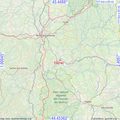
Vayrac GPS coordinates[2]
44° 57' 12.132" North, 1° 42' 12.888" East
| Map corner | latitude | longitude |
|---|---|---|
| Upper-left | 45.4488°, | 1.00045° |
| Center: | 44.95337°, | 1.70358° |
| Lower-right: | 44.45362°, | 2.4067° |
| Map W x H: | 110.7×110.7 km | = 68.8×68.8mi |
| max Lat: | 51.07786° ⇑80% North |
| Vayrac: | 44.95337° |
| min Lat: | ⇓20% South 41.3874° |
| min Long | Vayrac | max Long |
| -5.08615° | 1.70358° | 9.52242° |
| W 39.6%⇐ | ⇒60.4% E |
Elevation
Elevation of Vayrac is 141 m = 463 ft, and this is 52.7 m = 173 ft below average elevation for this country.
| Max E: |
2333 m = 7654 ft | 47.5% |
| Avg. | 193.7 m = 635 ft | |
| Vayrac | 141 m = 463 ft | |
Min E: |
-1 m = -3 ft | 52.5% |
See also: France elevation on elevation.city.
Geographical zone
Vayrac is located in North temperate zone (between Tropic of Cancer and the Arctic Circle). Distance of this Northern Tropic circle is 2392.4 km =1486.6 mi to South.| Distance of | km | miles | from Vayrac |
|---|---|---|---|
| North Pole | 5008.7 | 3112.3 | to North |
| Arctic Circle | 2402.8 | 1493 | to North |
| Tropic Cancer | 2392.4 | 1486.6 | to South |
| Equator | 4998.3 | 3105.8 | to South |


Nearby cities:
15 places around Vayrac: (largest is in red/bold)
• Altillac
11.7 km =7.3 mi,  76°
76°
• Alvignac
14 km =8.7 mi,  182°
182°
• Beaulieu-sur-Dordogne
11 km =6.8 mi, 75°
• Biars-sur-Cère
12.2 km =7.6 mi,  104°
104°
• Bretenoux
11.6 km =7.2 mi,  111°
111°
• Bétaille
2.6 km =1.6 mi, 113°
• Cressensac
16.3 km =10.1 mi,  298°
298°
• Lachapelle-Auzac
16.9 km =10.5 mi,  260°
260°
• Les Quatre-Routes-du-Lot
6.7 km =4.2 mi,  320°
320°
• Martel
7.7 km =4.8 mi, 256°
• Meyssac
11.6 km =7.2 mi,  348°
348°
• Prudhomat
11.4 km =7.1 mi,  122°
122°
• Puybrun
7.6 km =4.7 mi, 120°
• Sarrazac
11.4 km =7.1 mi,  308°
308°
• Turenne
14.7 km =9.1 mi, 319°
Sources, notices
• [Note1] Compared only with cities in France existing in our database
• [Src1] Map data: © OpenStreetMap contributors (CC-BY-SA)
• [Src2] Other city data from geonames.org with taken over terms of usage.
• [Src3] Geographical zone / Annual Mean Temperature by Robert A. Rohde @ Wikipedia
