Altillac geodata
Altillac (Nouvelle-Aquitaine) is a populated place; located in France in Europe/Paris (GMT+2) time zone. With population of 826 people, there are 10332 cities with bigger population in this country. Compared to other cities in France, 79.8% of cities are located further ↑North; 58.8% of cities are located further →East and 63.3% of cities have lower elevation than Altillac. Note1
Administrative division(s):
- Level 1: Nouvelle-Aquitaine
- Level 2: Département de la Corrèze
- Level 3: Arrondissement de Brive-la-Gaillarde
- Level 4: Altillac


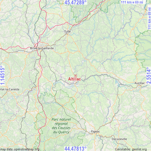
Altillac GPS coordinates[2]
44° 58' 39.612" North, 1° 50' 53.808" East
| Map corner | latitude | longitude |
|---|---|---|
| Upper-left | 45.47289°, | 1.14515° |
| Center: | 44.97767°, | 1.84828° |
| Lower-right: | 44.47813°, | 2.5514° |
| Map W x H: | 110.6×110.6 km | = 68.7×68.7mi |
| max Lat: | 51.07786° ⇑79.8% North |
| Altillac: | 44.97767° |
| min Lat: | ⇓20.2% South 41.3874° |
| min Long | Altillac | max Long |
| -5.08615° | 1.84828° | 9.52242° |
| W 41.2%⇐ | ⇒58.8% E |
Elevation
Elevation of Altillac is 186 m = 610 ft, and this is 7.7 m = 25 ft below average elevation for this country.
| Max E: |
2333 m = 7654 ft | 36.7% |
| Avg. | 193.7 m = 635 ft | |
| Altillac | 186 m = 610 ft | |
Min E: |
-1 m = -3 ft | 63.3% |
See also: France elevation on elevation.city.
Geographical zone
Altillac is located in North temperate zone (between Tropic of Cancer and the Arctic Circle). Distance of this Northern Tropic circle is 2395.1 km =1488.2 mi to South.| Distance of | km | miles | from Altillac |
|---|---|---|---|
| North Pole | 5006 | 3110.6 | to North |
| Arctic Circle | 2400.1 | 1491.4 | to North |
| Tropic Cancer | 2395.1 | 1488.2 | to South |
| Equator | 5001 | 3107.5 | to South |


Nearby cities:
15 places around Altillac: (largest is in red/bold)
• Albussac
17.9 km =11.1 mi,  356°
356°
• Argentat
14.6 km =9.1 mi,  28°
28°
• Beaulieu-sur-Dordogne
0.8 km =0.5 mi,  275°
275°
• Biars-sur-Cère
5.7 km =3.5 mi,  175°
175°
• Bretenoux
7 km =4.3 mi,  185°
185°
• Bétaille
9.7 km =6 mi,  247°
247°
• Les Quatre-Routes-du-Lot
15.8 km =9.8 mi, 279°
• Meyssac
16.2 km =10.1 mi,  302°
302°
• Monceaux-sur-Dordogne
12.5 km =7.8 mi,  21°
21°
• Prudhomat
9 km =5.6 mi, 191°
• Puybrun
8.1 km =5 mi,  216°
216°
• Saint-Chamant
16.9 km =10.5 mi,  12°
12°
• Saint-Céré
13.9 km =8.6 mi,  164°
164°
• Saint-Laurent-les-Tours
11.9 km =7.4 mi, 161°
• Vayrac
11.7 km =7.3 mi,  256°
256°
Sources, notices
• [Note1] Compared only with cities in France existing in our database
• [Src1] Map data: © OpenStreetMap contributors (CC-BY-SA)
• [Src2] Other city data from geonames.org with taken over terms of usage.
• [Src3] Geographical zone / Annual Mean Temperature by Robert A. Rohde @ Wikipedia
