Puybrun geodata
Puybrun (Occitanie) is a populated place; located in France in Europe/Paris (GMT+2) time zone. With population of 785 people, there are 10762 cities with bigger population in this country. Compared to other cities in France, 80.3% of cities are located further ↑North; 59.5% of cities are located further →East and 53.9% of cities have lower elevation than Puybrun. Note1
Administrative division(s):
- Level 1: Occitanie
- Level 2: Lot
- Level 3: Arrondissement de Figeac
- Level 4: Puybrun


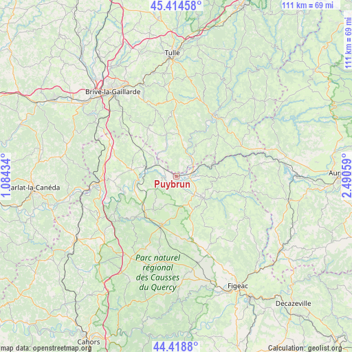
Puybrun GPS coordinates[2]
44° 55' 7.86" North, 1° 47' 14.892" East
| Map corner | latitude | longitude |
|---|---|---|
| Upper-left | 45.41458°, | 1.08434° |
| Center: | 44.91885°, | 1.78747° |
| Lower-right: | 44.4188°, | 2.49059° |
| Map W x H: | 110.7×110.7 km | = 68.8×68.8mi |
| max Lat: | 51.07786° ⇑80.3% North |
| Puybrun: | 44.91885° |
| min Lat: | ⇓19.7% South 41.3874° |
| min Long | Puybrun | max Long |
| -5.08615° | 1.78747° | 9.52242° |
| W 40.5%⇐ | ⇒59.5% E |
Elevation
Elevation of Puybrun is 146 m = 479 ft, and this is 47.7 m = 156 ft below average elevation for this country.
| Max E: |
2333 m = 7654 ft | 46.1% |
| Avg. | 193.7 m = 635 ft | |
| Puybrun | 146 m = 479 ft | |
Min E: |
-1 m = -3 ft | 53.9% |
See also: France elevation on elevation.city.
Geographical zone
Puybrun is located in North temperate zone (between Tropic of Cancer and the Arctic Circle). Distance of this Northern Tropic circle is 2388.6 km =1484.2 mi to South.| Distance of | km | miles | from Puybrun |
|---|---|---|---|
| North Pole | 5012.6 | 3114.7 | to North |
| Arctic Circle | 2406.7 | 1495.5 | to North |
| Tropic Cancer | 2388.6 | 1484.2 | to South |
| Equator | 4994.5 | 3103.4 | to South |


Nearby cities:
15 places around Puybrun: (largest is in red/bold)
• Altillac
8.1 km =5 mi,  36°
36°
• Alvignac
12.5 km =7.8 mi,  215°
215°
• Aynac
15.8 km =9.8 mi,  161°
161°
• Beaulieu-sur-Dordogne
7.7 km =4.8 mi,  31°
31°
• Biars-sur-Cère
5.3 km =3.3 mi,  81°
81°
• Bretenoux
4.2 km =2.6 mi,  96°
96°
• Bétaille
5.1 km =3.2 mi,  303°
303°
• Gramat
16.3 km =10.1 mi,  199°
199°
• Les Quatre-Routes-du-Lot
14.1 km =8.8 mi,  309°
309°
• Leyme
17.2 km =10.7 mi,  149°
149°
• Martel
14.2 km =8.8 mi,  278°
278°
• Prudhomat
3.8 km =2.4 mi,  126°
126°
• Saint-Céré
10.8 km =6.7 mi, 129°
• Saint-Laurent-les-Tours
9.8 km =6.1 mi,  118°
118°
• Vayrac
7.6 km =4.7 mi, 300°
Sources, notices
• [Note1] Compared only with cities in France existing in our database
• [Src1] Map data: © OpenStreetMap contributors (CC-BY-SA)
• [Src2] Other city data from geonames.org with taken over terms of usage.
• [Src3] Geographical zone / Annual Mean Temperature by Robert A. Rohde @ Wikipedia
