Bretenoux geodata
Bretenoux (Occitanie) is a populated place; located in France in Europe/Paris (GMT+2) time zone. With population of 1,346 people, there are 6833 cities with bigger population in this country. Compared to other cities in France, 80.4% of cities are located further ↑North; 58.9% of cities are located further →East and 51.4% of cities have lower elevation than Bretenoux. Note1
Administrative division(s):
- Level 1: Occitanie
- Level 2: Lot
- Level 3: Arrondissement de Figeac
- Level 4: Bretenoux


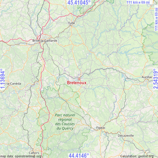
Bretenoux GPS coordinates[2]
44° 54' 52.848" North, 1° 50' 24.252" East
| Map corner | latitude | longitude |
|---|---|---|
| Upper-left | 45.41045°, | 1.13694° |
| Center: | 44.91468°, | 1.84007° |
| Lower-right: | 44.4146°, | 2.54319° |
| Map W x H: | 110.7×110.7 km | = 68.8×68.8mi |
| max Lat: | 51.07786° ⇑80.4% North |
| Bretenoux: | 44.91468° |
| min Lat: | ⇓19.6% South 41.3874° |
| min Long | Bretenoux | max Long |
| -5.08615° | 1.84007° | 9.52242° |
| W 41.1%⇐ | ⇒58.9% E |
Elevation
Elevation of Bretenoux is 137 m = 449 ft, and this is 56.7 m = 186 ft below average elevation for this country.
| Max E: |
2333 m = 7654 ft | 48.6% |
| Avg. | 193.7 m = 635 ft | |
| Bretenoux | 137 m = 449 ft | |
Min E: |
-1 m = -3 ft | 51.4% |
See also: France elevation on elevation.city.
Geographical zone
Bretenoux is located in North temperate zone (between Tropic of Cancer and the Arctic Circle). Distance of this Northern Tropic circle is 2388.1 km =1483.9 mi to South.| Distance of | km | miles | from Bretenoux |
|---|---|---|---|
| North Pole | 5013 | 3114.9 | to North |
| Arctic Circle | 2407.1 | 1495.7 | to North |
| Tropic Cancer | 2388.1 | 1483.9 | to South |
| Equator | 4994 | 3103.1 | to South |


Nearby cities:
15 places around Bretenoux: (largest is in red/bold)
• Altillac
7 km =4.3 mi,  5°
5°
• Alvignac
15 km =9.3 mi,  229°
229°
• Aynac
14.5 km =9 mi,  176°
176°
• Beaulieu-sur-Dordogne
7.1 km =4.4 mi,  358°
358°
• Biars-sur-Cère
1.7 km =1.1 mi,  40°
40°
• Bétaille
9 km =5.6 mi,  291°
291°
• Gramat
17.7 km =11 mi,  212°
212°
• Les Quatre-Routes-du-Lot
17.7 km =11 mi,  302°
302°
• Leyme
15 km =9.3 mi,  161°
161°
• Prudhomat
2.1 km =1.3 mi, 211°
• Puybrun
4.2 km =2.6 mi,  276°
276°
• Saint-Céré
7.7 km =4.8 mi,  146°
146°
• Saint-Laurent-les-Tours
6.1 km =3.8 mi,  133°
133°
• Sousceyrac
16.1 km =10 mi,  106°
106°
• Vayrac
11.6 km =7.2 mi, 291°
Sources, notices
• [Note1] Compared only with cities in France existing in our database
• [Src1] Map data: © OpenStreetMap contributors (CC-BY-SA)
• [Src2] Other city data from geonames.org with taken over terms of usage.
• [Src3] Geographical zone / Annual Mean Temperature by Robert A. Rohde @ Wikipedia
