Val-d’Isère geodata
Val-d’Isère (Auvergne-Rhône-Alpes) is a populated place; located in France in Europe/Paris (GMT+2) time zone. With population of 1,632 people, there are 5725 cities with bigger population in this country. Compared to other cities in France, 74.7% of cities are located further ↑North; 94.7% of cities are located further ←West and 100% of cities have lower elevation than Val-d’Isère. Note1
Administrative division(s):
- Level 1: Auvergne-Rhône-Alpes
- Level 2: Savoie
- Level 3: Albertville
- Level 4: Val-d'Isère


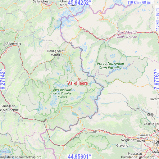
Val-d’Isère GPS coordinates[2]
45° 27' 5.112" North, 6° 58' 28.38" East
| Map corner | latitude | longitude |
|---|---|---|
| Upper-left | 45.94252°, | 6.27142° |
| Center: | 45.45142°, | 6.97455° |
| Lower-right: | 44.95601°, | 7.67767° |
| Map W x H: | 109.7×109.7 km | = 68.2×68.2mi |
| max Lat: | 51.07786° ⇑74.7% North |
| Val-d’Isère: | 45.45142° |
| min Lat: | ⇓25.3% South 41.3874° |
| min Long | Val-d’Isère | max Long |
| -5.08615° | 6.97455° | 9.52242° |
| W 94.7%⇐ | ⇒5.3% E |
Elevation
Elevation of Val-d’Isère is 1940 m = 6365 ft, and this is 1746.3 m = 5729 ft above average elevation for this country.
| Max E: |
2333 m = 7654 ft | 0% |
| Val-d’Isère | 1940 m 6365 ft | |
| Avg. | 193.7 m = 635 ft | |
Min E: |
-1 m = -3 ft | 100% |
See also: France elevation on elevation.city.
Geographical zone
Val-d’Isère is located in North temperate zone (between Tropic of Cancer and the Arctic Circle). Distance of this North polar circle is 2347.4 km =1458.6 mi to North.| Distance of | km | miles | from Val-d’Isère |
|---|---|---|---|
| North Pole | 4953.3 | 3077.8 | to North |
| Arctic Circle | 2347.4 | 1458.6 | to North |
| Tropic Cancer | 2447.8 | 1521 | to South |
| Equator | 5053.7 | 3140.2 | to South |


Nearby cities:
15 places around Val-d’Isère: (largest is in red/bold)
• Belle-Plagne
21.8 km =13.5 mi,  287°
287°
• Bellentre
24.2 km =15 mi,  302°
302°
• Bourg-Saint-Maurice
24.2 km =15 mi,  318°
318°
• Bozel
25.4 km =15.8 mi,  267°
267°
• Champagny-en-Vanoise
21.9 km =13.6 mi, 270°
• Landry
22.7 km =14.1 mi,  306°
306°
• Lanslebourg-Mont-Cenis
20 km =12.4 mi,  202°
202°
• Montvalezan
20.4 km =12.7 mi,  330°
330°
• Mâcot-la-Plagne
26.4 km =16.4 mi, 294°
• Peisey-Nancroix
20.1 km =12.5 mi, 301°
• Pralognan-la-Vanoise
21.4 km =13.3 mi,  249°
249°
• Saint-Bon-Tarentaise
26.4 km =16.4 mi, 265°
• Sainte-Foy-Tarentaise
16.8 km =10.4 mi,  335°
335°
• Séez
23.4 km =14.5 mi, 324°
• Tignes
6.3 km =3.9 mi, 321°
In other languages:
- In France: Val-d'Isère
- In German: Val-d'Isère
- In Italian: Val-d'Isère
- In Russian: Валь д'Изер
Sources, notices
• [Note1] Compared only with cities in France existing in our database
• [Src1] Map data: © OpenStreetMap contributors (CC-BY-SA)
• [Src2] Other city data from geonames.org with taken over terms of usage.
• [Src3] Geographical zone / Annual Mean Temperature by Robert A. Rohde @ Wikipedia
