Saint-Sardos geodata
Saint-Sardos (Occitanie) is a populated place; located in France in Europe/Paris (GMT+2) time zone. With population of 596 people, there are 13387 cities with bigger population in this country. Compared to other cities in France, 88% of cities are located further ↑North; 67.6% of cities are located further →East and 61.9% of cities have lower elevation than Saint-Sardos. Note1
Administrative division(s):
- Level 1: Occitanie
- Level 2: Département du Tarn-et-Garonne
- Level 3: Arrondissement de Montauban
- Level 4: Saint-Sardos


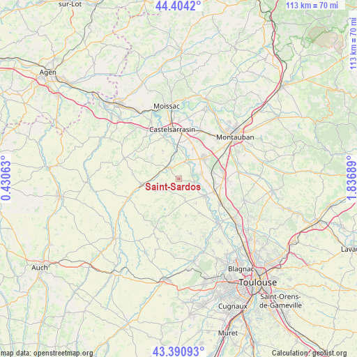
Saint-Sardos GPS coordinates[2]
43° 53' 58.992" North, 1° 8' 1.536" East
| Map corner | latitude | longitude |
|---|---|---|
| Upper-left | 44.4042°, | 0.43063° |
| Center: | 43.89972°, | 1.13376° |
| Lower-right: | 43.39093°, | 1.83689° |
| Map W x H: | 112.7×112.7 km | = 70×70mi |
| max Lat: | 51.07786° ⇑88% North |
| Saint-Sardos: | 43.89972° |
| min Lat: | ⇓12% South 41.3874° |
| min Long | Saint-Sardos | max Long |
| -5.08615° | 1.13376° | 9.52242° |
| W 32.4%⇐ | ⇒67.6% E |
Elevation
Elevation of Saint-Sardos is 179 m = 587 ft, and this is 14.7 m = 48 ft below average elevation for this country.
| Max E: |
2333 m = 7654 ft | 38.1% |
| Avg. | 193.7 m = 635 ft | |
| Saint-Sardos | 179 m = 587 ft | |
Min E: |
-1 m = -3 ft | 61.9% |
See also: France elevation on elevation.city.
Geographical zone
Saint-Sardos is located in North temperate zone (between Tropic of Cancer and the Arctic Circle). Distance of this Northern Tropic circle is 2275.3 km =1413.8 mi to South.| Distance of | km | miles | from Saint-Sardos |
|---|---|---|---|
| North Pole | 5125.9 | 3185.1 | to North |
| Arctic Circle | 2520 | 1565.9 | to North |
| Tropic Cancer | 2275.3 | 1413.8 | to South |
| Equator | 4881.2 | 3033 | to South |


Nearby cities:
15 places around Saint-Sardos: (largest is in red/bold)
• Beaumont-de-Lomagne
11.9 km =7.4 mi,  260°
260°
• Bessens
9.9 km =6.2 mi,  103°
103°
• Bourret
5.5 km =3.4 mi,  30°
30°
• Dieupentale
11.7 km =7.3 mi,  110°
110°
• Escatalens
10.4 km =6.5 mi, 25°
• Finhan
7.2 km =4.5 mi,  77°
77°
• Garganvillar
10.2 km =6.3 mi,  328°
328°
• Larrazet
5.3 km =3.3 mi,  310°
310°
• Mas-Grenier
5.1 km =3.2 mi, 100°
• Montbartier
11.4 km =7.1 mi, 82°
• Montech
10.2 km =6.3 mi,  50°
50°
• Saint-Porquier
12.1 km =7.5 mi,  17°
17°
• Savenès
9.2 km =5.7 mi,  145°
145°
• Sérignac
9.4 km =5.8 mi,  285°
285°
• Verdun-sur-Garonne
9.5 km =5.9 mi,  121°
121°
Sources, notices
• [Note1] Compared only with cities in France existing in our database
• [Src1] Map data: © OpenStreetMap contributors (CC-BY-SA)
• [Src2] Other city data from geonames.org with taken over terms of usage.
• [Src3] Geographical zone / Annual Mean Temperature by Robert A. Rohde @ Wikipedia
