Larrazet geodata
Larrazet (Occitanie) is a populated place; located in France in Europe/Paris (GMT+2) time zone. With population of 595 people, there are 13406 cities with bigger population in this country. Compared to other cities in France, 87.7% of cities are located further ↑North; 68% of cities are located further →East and 60.4% of cities have higher elevation than Larrazet. Note1
Administrative division(s):
- Level 1: Occitanie
- Level 2: Département du Tarn-et-Garonne
- Level 3: Arrondissement de Castelsarrasin
- Level 4: Larrazet


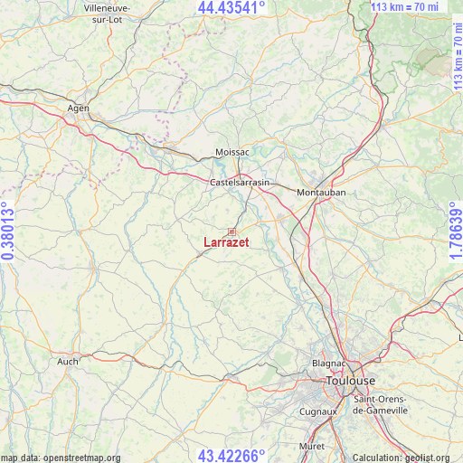
Larrazet GPS coordinates[2]
43° 55' 52.284" North, 1° 4' 59.736" East
| Map corner | latitude | longitude |
|---|---|---|
| Upper-left | 44.43541°, | 0.38013° |
| Center: | 43.93119°, | 1.08326° |
| Lower-right: | 43.42266°, | 1.78639° |
| Map W x H: | 112.6×112.6 km | = 70×70mi |
| max Lat: | 51.07786° ⇑87.7% North |
| Larrazet: | 43.93119° |
| min Lat: | ⇓12.3% South 41.3874° |
| min Long | Larrazet | max Long |
| -5.08615° | 1.08326° | 9.52242° |
| W 32%⇐ | ⇒68% E |
Elevation
Elevation of Larrazet is 101 m = 331 ft, and this is 92.7 m = 304 ft below average elevation for this country.
| Max E: |
2333 m = 7654 ft | 60.4% |
| Avg. | 193.7 m = 635 ft | |
| Larrazet | 101 m = 331 ft | |
Min E: |
-1 m = -3 ft | 39.6% |
See also: France elevation on elevation.city.
Geographical zone
Larrazet is located in North temperate zone (between Tropic of Cancer and the Arctic Circle). Distance of this Northern Tropic circle is 2278.8 km =1416 mi to South.| Distance of | km | miles | from Larrazet |
|---|---|---|---|
| North Pole | 5122.4 | 3182.9 | to North |
| Arctic Circle | 2516.5 | 1563.7 | to North |
| Tropic Cancer | 2278.8 | 1416 | to South |
| Equator | 4884.7 | 3035.2 | to South |


Nearby cities:
15 places around Larrazet: (largest is in red/bold)
• Beaumont-de-Lomagne
9.4 km =5.8 mi,  234°
234°
• Bourret
6.9 km =4.3 mi,  79°
79°
• Castelmayran
11.5 km =7.1 mi,  342°
342°
• Castelsarrasin
12.3 km =7.6 mi,  8°
8°
• Escatalens
10.3 km =6.4 mi,  54°
54°
• Finhan
11.2 km =7 mi,  100°
100°
• Garganvillar
5.4 km =3.4 mi,  346°
346°
• Lavit
13.4 km =8.3 mi,  282°
282°
• Mas-Grenier
10.1 km =6.3 mi,  115°
115°
• Montech
12.3 km =7.6 mi, 75°
• Saint-Porquier
11.1 km =6.9 mi,  43°
43°
• Saint-Sardos
5.3 km =3.3 mi,  130°
130°
• Savenès
14.4 km =8.9 mi,  140°
140°
• Sérignac
5.1 km =3.2 mi,  259°
259°
• Verdun-sur-Garonne
14.8 km =9.2 mi, 125°
Sources, notices
• [Note1] Compared only with cities in France existing in our database
• [Src1] Map data: © OpenStreetMap contributors (CC-BY-SA)
• [Src2] Other city data from geonames.org with taken over terms of usage.
• [Src3] Geographical zone / Annual Mean Temperature by Robert A. Rohde @ Wikipedia
