Neffes geodata
Neffes (Provence-Alpes-Côte d'Azur) is a populated place; located in France in Europe/Paris (GMT+2) time zone. With population of 697 people, there are 11838 cities with bigger population in this country. Compared to other cities in France, 83.5% of cities are located further ↑North; 87.3% of cities are located further ←West and 97.3% of cities have lower elevation than Neffes. Note1
Administrative division(s):
- Level 1: Provence-Alpes-Côte d'Azur
- Level 2: Hautes-Alpes
- Level 3: Arrondissement de Gap
- Level 4: Neffes


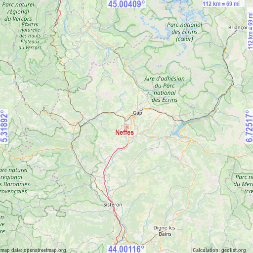
Neffes GPS coordinates[2]
44° 30' 17.208" North, 6° 1' 19.344" East
| Map corner | latitude | longitude |
|---|---|---|
| Upper-left | 45.00409°, | 5.31892° |
| Center: | 44.50478°, | 6.02204° |
| Lower-right: | 44.00116°, | 6.72517° |
| Map W x H: | 111.5×111.5 km | = 69.3×69.3mi |
| max Lat: | 51.07786° ⇑83.5% North |
| Neffes: | 44.50478° |
| min Lat: | ⇓16.5% South 41.3874° |
| min Long | Neffes | max Long |
| -5.08615° | 6.02204° | 9.52242° |
| W 87.3%⇐ | ⇒12.7% E |
Elevation
Elevation of Neffes is 754 m = 2474 ft, and this is 560.3 m = 1838 ft above average elevation for this country.
| Max E: |
2333 m = 7654 ft | 2.7% |
| Neffes | 754 m 2474 ft | |
| Avg. | 193.7 m = 635 ft | |
Min E: |
-1 m = -3 ft | 97.3% |
See also: France elevation on elevation.city.
Geographical zone
Neffes is located in North temperate zone (between Tropic of Cancer and the Arctic Circle). Distance of this Northern Tropic circle is 2342.5 km =1455.6 mi to South.| Distance of | km | miles | from Neffes |
|---|---|---|---|
| North Pole | 5058.6 | 3143.3 | to North |
| Arctic Circle | 2452.7 | 1524 | to North |
| Tropic Cancer | 2342.5 | 1455.6 | to South |
| Equator | 4948.5 | 3074.9 | to South |


Nearby cities:
15 places around Neffes: (largest is in red/bold)
• Ancelle
19.7 km =12.2 mi,  47°
47°
• Aspres-sur-Buëch
21.4 km =13.3 mi,  275°
275°
• Chabottes
20.7 km =12.9 mi,  36°
36°
• Chorges
20.8 km =12.9 mi,  76°
76°
• Espinasses
17.1 km =10.6 mi,  104°
104°
• Gap
7.5 km =4.7 mi, 36°
• La Bâtie-Neuve
15.4 km =9.6 mi,  63°
63°
• La Motte-du-Caire
17.9 km =11.1 mi,  178°
178°
• La Roche-des-Arnauds
8.3 km =5.2 mi,  320°
320°
• La Saulce
8.9 km =5.5 mi,  187°
187°
• Saint-Bonnet-en-Champsaur
20.4 km =12.7 mi,  13°
13°
• Sigoyer
4.7 km =2.9 mi,  230°
230°
• Tallard
5.3 km =3.3 mi,  153°
153°
• Ventavon
17.5 km =10.9 mi,  211°
211°
• Veynes
16.1 km =10 mi, 281°
Sources, notices
• [Note1] Compared only with cities in France existing in our database
• [Src1] Map data: © OpenStreetMap contributors (CC-BY-SA)
• [Src2] Other city data from geonames.org with taken over terms of usage.
• [Src3] Geographical zone / Annual Mean Temperature by Robert A. Rohde @ Wikipedia
