Le Dévoluy geodata
Le Dévoluy (Provence-Alpes-Côte d'Azur) is a seat of a fourth-order administrative division; located in France in Europe/Paris (GMT+2) time zone. With population of 537 people, there are 14448 cities with bigger population in this country. Compared to other cities in France, 82.1% of cities are located further ↑North; 86.4% of cities are located further ←West and 99.7% of cities have lower elevation than Le Dévoluy. Note1
Administrative division(s):
- Level 1: Provence-Alpes-Côte d'Azur
- Level 2: Hautes-Alpes
- Level 3: Arrondissement de Gap
- Level 4: Dévoluy


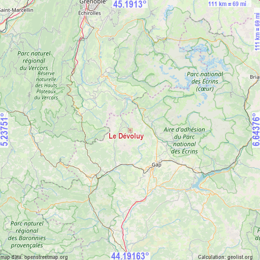
Le Dévoluy GPS coordinates[2]
44° 41' 37.032" North, 5° 56' 26.268" East
| Map corner | latitude | longitude |
|---|---|---|
| Upper-left | 45.1913°, | 5.23751° |
| Center: | 44.69362°, | 5.94063° |
| Lower-right: | 44.19163°, | 6.64376° |
| Map W x H: | 111.2×111.2 km | = 69.1×69.1mi |
| max Lat: | 51.07786° ⇑82.1% North |
| Le Dévoluy: | 44.69362° |
| min Lat: | ⇓17.9% South 41.3874° |
| min Long | Le Dévoluy | max Long |
| -5.08615° | 5.94063° | 9.52242° |
| W 86.4%⇐ | ⇒13.6% E |
Elevation
Elevation of Le Dévoluy is 1274 m = 4180 ft, and this is 1080.3 m = 3544 ft above average elevation for this country.
| Max E: |
2333 m = 7654 ft | 0.3% |
| Le Dévoluy | 1274 m 4180 ft | |
| Avg. | 193.7 m = 635 ft | |
Min E: |
-1 m = -3 ft | 99.7% |
See also: France elevation on elevation.city.
Geographical zone
Le Dévoluy is located in North temperate zone (between Tropic of Cancer and the Arctic Circle). Distance of this Northern Tropic circle is 2363.5 km =1468.6 mi to South.| Distance of | km | miles | from Le Dévoluy |
|---|---|---|---|
| North Pole | 5037.6 | 3130.2 | to North |
| Arctic Circle | 2431.7 | 1511 | to North |
| Tropic Cancer | 2363.5 | 1468.6 | to South |
| Equator | 4969.5 | 3087.9 | to South |


Nearby cities:
15 places around Le Dévoluy: (largest is in red/bold)
• Ancelle
22.4 km =13.9 mi,  110°
110°
• Aspres-sur-Buëch
24.2 km =15 mi,  217°
217°
• Chabottes
19.1 km =11.9 mi,  103°
103°
• Gap
18.6 km =11.6 mi,  143°
143°
• La Bâtie-Neuve
24.6 km =15.3 mi,  124°
124°
• La Mure
26 km =16.2 mi,  332°
332°
• La Roche-des-Arnauds
14.7 km =9.1 mi,  175°
175°
• Mens
20.2 km =12.6 mi,  312°
312°
• Neffes
22 km =13.7 mi,  162°
162°
• Saint-Bonnet-en-Champsaur
11.3 km =7 mi, 95°
• Saint-Honoré
29.4 km =18.3 mi,  340°
340°
• Saint-Jean
22 km =13.7 mi, 96°
• Sigoyer
24.1 km =15 mi,  173°
173°
• Tallard
27.2 km =16.9 mi, 161°
• Veynes
20 km =12.4 mi,  207°
207°
Sources, notices
• [Note1] Compared only with cities in France existing in our database
• [Src1] Map data: © OpenStreetMap contributors (CC-BY-SA)
• [Src2] Other city data from geonames.org with taken over terms of usage.
• [Src3] Geographical zone / Annual Mean Temperature by Robert A. Rohde @ Wikipedia
