Gap geodata
Gap (Provence-Alpes-Côte d'Azur) is a seat of a second-order administrative division; located in France in Europe/Paris (GMT+2) time zone. With population of 42,715 people, there are 166 cities with bigger population in this country. Compared to other cities in France, 83.1% of cities are located further ↑North; 87.9% of cities are located further ←West and 97.3% of cities have lower elevation than Gap. Note1
Administrative division(s):
- Level 1: Provence-Alpes-Côte d'Azur
- Level 2: Hautes-Alpes
- Level 3: Arrondissement de Gap
- Level 4: Gap


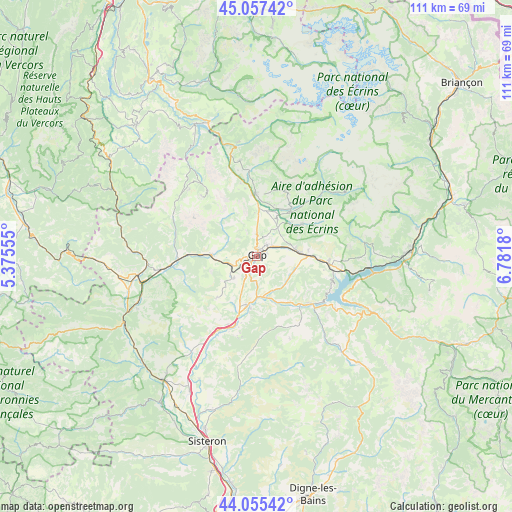
Gap GPS coordinates[2]
44° 33' 30.888" North, 6° 4' 43.248" East
| Map corner | latitude | longitude |
|---|---|---|
| Upper-left | 45.05742°, | 5.37555° |
| Center: | 44.55858°, | 6.07868° |
| Lower-right: | 44.05542°, | 6.7818° |
| Map W x H: | 111.4×111.4 km | = 69.2×69.2mi |
| max Lat: | 51.07786° ⇑83.1% North |
| Gap: | 44.55858° |
| min Lat: | ⇓16.9% South 41.3874° |
| min Long | Gap | max Long |
| -5.08615° | 6.07868° | 9.52242° |
| W 87.9%⇐ | ⇒12.1% E |
Elevation
Elevation of Gap is 743 m = 2438 ft, and this is 549.3 m = 1802 ft above average elevation for this country.
| Max E: |
2333 m = 7654 ft | 2.7% |
| Gap | 743 m 2438 ft | |
| Avg. | 193.7 m = 635 ft | |
Min E: |
-1 m = -3 ft | 97.3% |
See also: Gap elevation on elevation.city.
Geographical zone
Gap is located in North temperate zone (between Tropic of Cancer and the Arctic Circle). Distance of this Northern Tropic circle is 2348.5 km =1459.3 mi to South.| Distance of | km | miles | from Gap |
|---|---|---|---|
| North Pole | 5052.6 | 3139.5 | to North |
| Arctic Circle | 2446.7 | 1520.3 | to North |
| Tropic Cancer | 2348.5 | 1459.3 | to South |
| Equator | 4954.4 | 3078.5 | to South |


Nearby cities:
15 places around Gap: (largest is in red/bold)
• Ancelle
12.4 km =7.7 mi,  54°
54°
• Chabottes
13.2 km =8.2 mi,  35°
35°
• Chorges
15.8 km =9.8 mi,  93°
93°
• Espinasses
15.8 km =9.8 mi,  130°
130°
• La Bâtie-Neuve
9.3 km =5.8 mi,  84°
84°
• La Roche-des-Arnauds
9.8 km =6.1 mi,  272°
272°
• La Saulce
15.9 km =9.9 mi,  201°
201°
• Le Dévoluy
18.6 km =11.6 mi,  323°
323°
• Neffes
7.5 km =4.7 mi,  216°
216°
• Orcières
24 km =14.9 mi, 54°
• Saint-Bonnet-en-Champsaur
13.9 km =8.6 mi,  1°
1°
• Saint-Jean
16.5 km =10.3 mi, 41°
• Sigoyer
12.1 km =7.5 mi, 222°
• Tallard
10.9 km =6.8 mi,  191°
191°
• Veynes
20.4 km =12.7 mi,  262°
262°
Sources, notices
• [Note1] Compared only with cities in France existing in our database
• [Src1] Map data: © OpenStreetMap contributors (CC-BY-SA)
• [Src2] Other city data from geonames.org with taken over terms of usage.
• [Src3] Geographical zone / Annual Mean Temperature by Robert A. Rohde @ Wikipedia
