Laroque geodata
Laroque (Occitanie) is a populated place; located in France in Europe/Paris (GMT+2) time zone. With population of 1,265 people, there are 7209 cities with bigger population in this country. Compared to other cities in France, 87.8% of cities are located further ↑North; 65.9% of cities are located further ←West and 54.5% of cities have lower elevation than Laroque. Note1
Administrative division(s):
- Level 1: Occitanie
- Level 2: Département de l'Hérault
- Level 3: Arrondissement de Lodève
- Level 4: Laroque


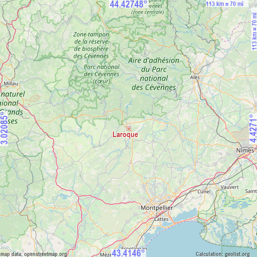
Laroque GPS coordinates[2]
43° 55' 23.52" North, 3° 43' 26.292" East
| Map corner | latitude | longitude |
|---|---|---|
| Upper-left | 44.42748°, | 3.02085° |
| Center: | 43.9232°, | 3.72397° |
| Lower-right: | 43.4146°, | 4.4271° |
| Map W x H: | 112.6×112.6 km | = 70×70mi |
| max Lat: | 51.07786° ⇑87.8% North |
| Laroque: | 43.9232° |
| min Lat: | ⇓12.2% South 41.3874° |
| min Long | Laroque | max Long |
| -5.08615° | 3.72397° | 9.52242° |
| W 65.9%⇐ | ⇒34.1% E |
Elevation
Elevation of Laroque is 148 m = 486 ft, and this is 45.7 m = 150 ft below average elevation for this country.
| Max E: |
2333 m = 7654 ft | 45.5% |
| Avg. | 193.7 m = 635 ft | |
| Laroque | 148 m = 486 ft | |
Min E: |
-1 m = -3 ft | 54.5% |
See also: France elevation on elevation.city.
Geographical zone
Laroque is located in North temperate zone (between Tropic of Cancer and the Arctic Circle). Distance of this Northern Tropic circle is 2277.9 km =1415.4 mi to South.| Distance of | km | miles | from Laroque |
|---|---|---|---|
| North Pole | 5123.3 | 3183.5 | to North |
| Arctic Circle | 2517.4 | 1564.2 | to North |
| Tropic Cancer | 2277.9 | 1415.4 | to South |
| Equator | 4883.8 | 3034.7 | to South |


Nearby cities:
15 places around Laroque: (largest is in red/bold)
• Avèze
11.2 km =7 mi,  298°
298°
• Brissac
5.3 km =3.3 mi,  198°
198°
• Cazilhac
1.7 km =1.1 mi,  259°
259°
• Claret
16 km =9.9 mi,  114°
114°
• Ganges
1.7 km =1.1 mi,  312°
312°
• Lasalle
17.1 km =10.6 mi,  37°
37°
• Le Vigan
12.2 km =7.6 mi, 308°
• Molières-Cavaillac
13.1 km =8.1 mi, 296°
• Monoblet
15.6 km =9.7 mi,  56°
56°
• Pompignan
11.1 km =6.9 mi, 107°
• Saint-André-de-Majencoules
12.3 km =7.6 mi,  341°
341°
• Saint-Bauzille-de-Putois
3.3 km =2.1 mi,  163°
163°
• Saint-Hippolyte-du-Fort
11.5 km =7.1 mi,  66°
66°
• Saint-Martin-de-Londres
14.8 km =9.2 mi,  177°
177°
• Sumène
6.4 km =4 mi,  354°
354°
Sources, notices
• [Note1] Compared only with cities in France existing in our database
• [Src1] Map data: © OpenStreetMap contributors (CC-BY-SA)
• [Src2] Other city data from geonames.org with taken over terms of usage.
• [Src3] Geographical zone / Annual Mean Temperature by Robert A. Rohde @ Wikipedia
