Lignac geodata
Lignac (Centre) is a populated place; located in France in Europe/Paris (GMT+2) time zone. With population of 592 people, there are 13451 cities with bigger population in this country. Compared to other cities in France, 60.4% of cities are located further ↑North; 66.5% of cities are located further →East and 56.1% of cities have lower elevation than Lignac. Note1
Administrative division(s):
- Level 1: Centre
- Level 2: Département de l'Indre
- Level 3: Le Blanc
- Level 4: Lignac


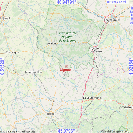
Lignac GPS coordinates[2]
46° 27' 56.736" North, 1° 13' 6.276" East
| Map corner | latitude | longitude |
|---|---|---|
| Upper-left | 46.94791°, | 0.51529° |
| Center: | 46.46576°, | 1.21841° |
| Lower-right: | 45.9793°, | 1.92154° |
| Map W x H: | 107.7×107.7 km | = 66.9×66.9mi |
| max Lat: | 51.07786° ⇑60.4% North |
| Lignac: | 46.46576° |
| min Lat: | ⇓39.6% South 41.3874° |
| min Long | Lignac | max Long |
| -5.08615° | 1.21841° | 9.52242° |
| W 33.5%⇐ | ⇒66.5% E |
Elevation
Elevation of Lignac is 154 m = 505 ft, and this is 39.7 m = 130 ft below average elevation for this country.
| Max E: |
2333 m = 7654 ft | 43.9% |
| Avg. | 193.7 m = 635 ft | |
| Lignac | 154 m = 505 ft | |
Min E: |
-1 m = -3 ft | 56.1% |
See also: France elevation on elevation.city.
Geographical zone
Lignac is located in North temperate zone (between Tropic of Cancer and the Arctic Circle). Distance of this North polar circle is 2234.7 km =1388.6 mi to North.| Distance of | km | miles | from Lignac |
|---|---|---|---|
| North Pole | 4840.6 | 3007.8 | to North |
| Arctic Circle | 2234.7 | 1388.6 | to North |
| Tropic Cancer | 2560.6 | 1591.1 | to South |
| Equator | 5166.5 | 3210.3 | to South |


Nearby cities:
15 places around Lignac: (largest is in red/bold)
• Brigueil-le-Chantre
12.7 km =7.9 mi,  232°
232°
• Bélâbre
10.6 km =6.6 mi,  334°
334°
• Béthines
20.7 km =12.9 mi,  296°
296°
• Chaillac
7.1 km =4.4 mi,  119°
119°
• Ciron
18.1 km =11.2 mi,  6°
6°
• Concremiers
21.2 km =13.2 mi,  313°
313°
• La Châtre-Langlin
14.6 km =9.1 mi, 115°
• La Trimouille
13.6 km =8.5 mi,  270°
270°
• Lussac-les-Églises
13.8 km =8.6 mi,  194°
194°
• Parnac
17.2 km =10.7 mi,  94°
94°
• Prissac
8.5 km =5.3 mi,  54°
54°
• Ruffec
18.6 km =11.6 mi,  348°
348°
• Saint-Benoît-du-Sault
13.5 km =8.4 mi,  102°
102°
• Saint-Léger-Magnazeix
19.9 km =12.4 mi,  173°
173°
• Saint-Sulpice-les-Feuilles
20 km =12.4 mi,  145°
145°
Sources, notices
• [Note1] Compared only with cities in France existing in our database
• [Src1] Map data: © OpenStreetMap contributors (CC-BY-SA)
• [Src2] Other city data from geonames.org with taken over terms of usage.
• [Src3] Geographical zone / Annual Mean Temperature by Robert A. Rohde @ Wikipedia
