Canon geodata
Canon (Normandy) is a populated place; located in France in Europe/Paris (GMT+2) time zone. With population of 4,926 people, there are 2008 cities with bigger population in this country. Compared to other cities in France, 81.5% of cities are located further ↓South; 78.8% of cities are located further →East and 89.5% of cities have higher elevation than Canon. Note1
Administrative division(s):
- Level 1: Normandy
- Level 2: Calvados
- Level 3: Arrondissement de Lisieux
- Level 4: Mézidon Vallée d'Auge


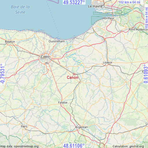
Canon GPS coordinates[2]
49° 4' 25.68" North, 0° 5' 31.884" West
| Map corner | latitude | longitude |
|---|---|---|
| Upper-left | 49.53227°, | -0.79531° |
| Center: | 49.0738°, | -0.09219° |
| Lower-right: | 48.61106°, | 0.61093° |
| Map W x H: | 102.4×102.4 km | = 63.6×63.6mi |
| max Lat: | 51.07786° ⇑18.5% North |
| Canon: | 49.0738° |
| min Lat: | ⇓81.5% South 41.3874° |
| min Long | Canon | max Long |
| -5.08615° | -0.09219° | 9.52242° |
| W 21.2%⇐ | ⇒78.8% E |
Elevation
Elevation of Canon is 31 m = 102 ft, and this is 162.7 m = 534 ft below average elevation for this country.
| Max E: |
2333 m = 7654 ft | 89.5% |
| Avg. | 193.7 m = 635 ft | |
| Canon | 31 m = 102 ft | |
Min E: |
-1 m = -3 ft | 10.5% |
See also: France elevation on elevation.city.
Geographical zone
Canon is located in North temperate zone (between Tropic of Cancer and the Arctic Circle). Distance of this North polar circle is 1944.7 km =1208.4 mi to North.| Distance of | km | miles | from Canon |
|---|---|---|---|
| North Pole | 4550.6 | 2827.6 | to North |
| Arctic Circle | 1944.7 | 1208.4 | to North |
| Tropic Cancer | 2850.6 | 1771.3 | to South |
| Equator | 5456.5 | 3390.5 | to South |


Nearby cities:
15 places around Canon: (largest is in red/bold)
• Airan
5.3 km =3.3 mi,  304°
304°
• Argences
8 km =5 mi,  317°
317°
• Bellengreville
10.2 km =6.3 mi, 303°
• Chicheboville
9.8 km =6.1 mi,  293°
293°
• Crevecoeur-en-Auge
9.2 km =5.7 mi,  58°
58°
• Le Mesnil-Mauger
7.9 km =4.9 mi,  81°
81°
• Magny-la-Campagne
2.9 km =1.8 mi,  196°
196°
• Moult
7 km =4.3 mi,  310°
310°
• Méry-Corbon
6.9 km =4.3 mi,  5°
5°
• Saint-Julien-le-Faucon
12.9 km =8 mi,  91°
91°
• Saint-Pierre-sur-Dives
7.7 km =4.8 mi,  145°
145°
• Saint-Sylvain
9.3 km =5.8 mi,  257°
257°
• Troarn
13.3 km =8.3 mi,  330°
330°
• Vendeuvre
9.3 km =5.8 mi,  172°
172°
• Vimont
9.5 km =5.9 mi, 304°
Sources, notices
• [Note1] Compared only with cities in France existing in our database
• [Src1] Map data: © OpenStreetMap contributors (CC-BY-SA)
• [Src2] Other city data from geonames.org with taken over terms of usage.
• [Src3] Geographical zone / Annual Mean Temperature by Robert A. Rohde @ Wikipedia
