Le Mesnil-Mauger geodata
Le Mesnil-Mauger (Normandy) is a populated place; located in France in Europe/Paris (GMT+2) time zone. With population of 992 people, there are 8887 cities with bigger population in this country. Compared to other cities in France, 81.8% of cities are located further ↓South; 78% of cities are located further →East and 93.1% of cities have higher elevation than Le Mesnil-Mauger. Note1
Administrative division(s):
- Level 1: Normandy
- Level 2: Calvados
- Level 3: Arrondissement de Lisieux
- Level 4: Mézidon Vallée d'Auge


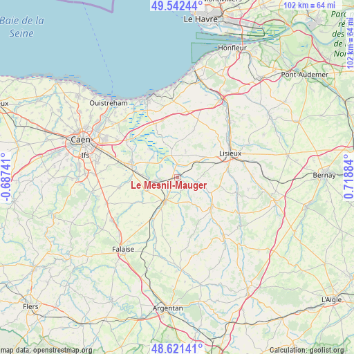
Le Mesnil-Mauger GPS coordinates[2]
49° 5' 2.616" North, 0° 0' 56.556" East
| Map corner | latitude | longitude |
|---|---|---|
| Upper-left | 49.54244°, | -0.68741° |
| Center: | 49.08406°, | 0.01571° |
| Lower-right: | 48.62141°, | 0.71884° |
| Map W x H: | 102.4×102.4 km | = 63.6×63.6mi |
| max Lat: | 51.07786° ⇑18.2% North |
| Le Mesnil-Mauger: | 49.08406° |
| min Lat: | ⇓81.8% South 41.3874° |
| min Long | Le Mesnil-Mauge | max Long |
| -5.08615° | 0.01571° | 9.52242° |
| W 22%⇐ | ⇒78% E |
Elevation
Elevation of Le Mesnil-Mauger is 22 m = 72 ft, and this is 171.7 m = 563 ft below average elevation for this country.
| Max E: |
2333 m = 7654 ft | 93.1% |
| Avg. | 193.7 m = 635 ft | |
| Le Mesnil-Mauger | 22 m = 72 ft | |
Min E: |
-1 m = -3 ft | 6.9% |
See also: France elevation on elevation.city.
Geographical zone
Le Mesnil-Mauger is located in North temperate zone (between Tropic of Cancer and the Arctic Circle). Distance of this North polar circle is 1943.5 km =1207.6 mi to North.| Distance of | km | miles | from Le Mesnil-Mauger |
|---|---|---|---|
| North Pole | 4549.4 | 2826.9 | to North |
| Arctic Circle | 1943.5 | 1207.6 | to North |
| Tropic Cancer | 2851.7 | 1772 | to South |
| Equator | 5457.6 | 3391.2 | to South |


Nearby cities:
15 places around Le Mesnil-Mauger: (largest is in red/bold)
• Airan
12.4 km =7.7 mi,  278°
278°
• Argences
14.1 km =8.8 mi,  289°
289°
• Bonnebosq
14 km =8.7 mi,  18°
18°
• Cambremer
7.9 km =4.9 mi, 17°
• Canon
7.9 km =4.9 mi,  261°
261°
• Crevecoeur-en-Auge
3.6 km =2.2 mi,  1°
1°
• Livarot
13.2 km =8.2 mi,  131°
131°
• Magny-la-Campagne
9.6 km =6 mi,  245°
245°
• Moult
13.6 km =8.5 mi, 284°
• Méry-Corbon
9.2 km =5.7 mi,  308°
308°
• Notre-Dame-de-Fresnay
13.6 km =8.5 mi,  171°
171°
• Saint-Germain-de-Livet
13.6 km =8.5 mi,  93°
93°
• Saint-Julien-le-Faucon
5.3 km =3.3 mi,  107°
107°
• Saint-Pierre-sur-Dives
8.3 km =5.2 mi,  205°
205°
• Vendeuvre
12.3 km =7.6 mi, 212°
Sources, notices
• [Note1] Compared only with cities in France existing in our database
• [Src1] Map data: © OpenStreetMap contributors (CC-BY-SA)
• [Src2] Other city data from geonames.org with taken over terms of usage.
• [Src3] Geographical zone / Annual Mean Temperature by Robert A. Rohde @ Wikipedia
