Malesherbes geodata
Malesherbes (Centre) is a populated place; located in France in Europe/Paris (GMT+2) time zone. With population of 6,335 people, there are 1564 cities with bigger population in this country. Compared to other cities in France, 64.4% of cities are located further ↓South; 51% of cities are located further →East and 56.9% of cities have higher elevation than Malesherbes. Note1
Administrative division(s):
- Level 1: Centre
- Level 2: Loiret
- Level 3: Arrondissement de Pithiviers
- Level 4: Le Malesherbois


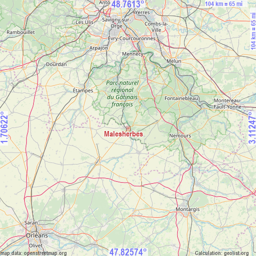
Malesherbes GPS coordinates[2]
48° 17' 44.376" North, 2° 24' 33.66" East
| Map corner | latitude | longitude |
|---|---|---|
| Upper-left | 48.7613°, | 1.70622° |
| Center: | 48.29566°, | 2.40935° |
| Lower-right: | 47.82574°, | 3.11247° |
| Map W x H: | 104×104 km | = 64.6×64.6mi |
| max Lat: | 51.07786° ⇑35.6% North |
| Malesherbes: | 48.29566° |
| min Lat: | ⇓64.4% South 41.3874° |
| min Long | Malesherbes | max Long |
| -5.08615° | 2.40935° | 9.52242° |
| W 49%⇐ | ⇒51% E |
Elevation
Elevation of Malesherbes is 111 m = 364 ft, and this is 82.7 m = 271 ft below average elevation for this country.
| Max E: |
2333 m = 7654 ft | 56.9% |
| Avg. | 193.7 m = 635 ft | |
| Malesherbes | 111 m = 364 ft | |
Min E: |
-1 m = -3 ft | 43.1% |
See also: France elevation on elevation.city.
Geographical zone
Malesherbes is located in North temperate zone (between Tropic of Cancer and the Arctic Circle). Distance of this North polar circle is 2031.2 km =1262.1 mi to North.| Distance of | km | miles | from Malesherbes |
|---|---|---|---|
| North Pole | 4637.1 | 2881.4 | to North |
| Arctic Circle | 2031.2 | 1262.1 | to North |
| Tropic Cancer | 2764.1 | 1717.5 | to South |
| Equator | 5370 | 3336.8 | to South |


Nearby cities:
15 places around Malesherbes: (largest is in red/bold)
• Achères-la-Forêt
13.6 km =8.5 mi,  61°
61°
• Aulnay-la-Rivière
12.1 km =7.5 mi,  194°
194°
• Briarres-sur-Essonne
7 km =4.3 mi,  175°
175°
• Buno-Bonnevaux
6.9 km =4.3 mi,  346°
346°
• Buthiers
1.9 km =1.2 mi,  119°
119°
• Estouy
13.4 km =8.3 mi,  206°
206°
• Gironville-sur-Essonne
8.1 km =5 mi, 346°
• La Chapelle-la-Reine
12.3 km =7.6 mi,  78°
78°
• Le Vaudoué
10.6 km =6.6 mi,  49°
49°
• Maisse
11.3 km =7 mi, 348°
• Manchecourt
8 km =5 mi,  217°
217°
• Milly-la-Forêt
12.9 km =8 mi,  20°
20°
• Noisy-sur-École
10.8 km =6.7 mi,  42°
42°
• Oncy-sur-École
10.6 km =6.6 mi, 23°
• Valpuiseaux
13.4 km =8.3 mi,  324°
324°
Sources, notices
• [Note1] Compared only with cities in France existing in our database
• [Src1] Map data: © OpenStreetMap contributors (CC-BY-SA)
• [Src2] Other city data from geonames.org with taken over terms of usage.
• [Src3] Geographical zone / Annual Mean Temperature by Robert A. Rohde @ Wikipedia
