Le Vigan geodata
Le Vigan (Occitanie) is a seat of a third-order administrative division; located in France in Europe/Paris (GMT+2) time zone. In our database, there are 15246 cities with bigger population. Compared to other cities in France, 87.1% of cities are located further ↑North; 65.1% of cities are located further ←West and 78.4% of cities have lower elevation than Le Vigan. Note1
Administrative division(s):
- Level 1: Occitanie
- Level 2: Gard
- Level 3: Arrondissement du Vigan
- Level 4: Le Vigan


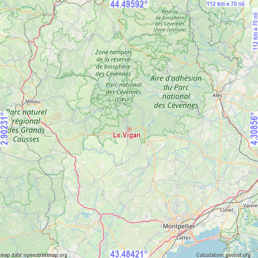
Le Vigan GPS coordinates[2]
43° 59' 31.992" North, 3° 36' 19.548" East
| Map corner | latitude | longitude |
|---|---|---|
| Upper-left | 44.49592°, | 2.90231° |
| Center: | 43.99222°, | 3.60543° |
| Lower-right: | 43.48421°, | 4.30856° |
| Map W x H: | 112.5×112.5 km | = 69.9×69.9mi |
| max Lat: | 51.07786° ⇑87.1% North |
| Le Vigan: | 43.99222° |
| min Lat: | ⇓12.9% South 41.3874° |
| min Long | Le Vigan | max Long |
| -5.08615° | 3.60543° | 9.52242° |
| W 65.1%⇐ | ⇒34.9% E |
Elevation
Elevation of Le Vigan is 275 m = 902 ft, and this is 81.3 m = 267 ft above average elevation for this country.
| Max E: |
2333 m = 7654 ft | 21.6% |
| Le Vigan | 275 m 902 ft | |
| Avg. | 193.7 m = 635 ft | |
Min E: |
-1 m = -3 ft | 78.4% |
See also: France elevation on elevation.city.
Geographical zone
Le Vigan is located in North temperate zone (between Tropic of Cancer and the Arctic Circle). Distance of this Northern Tropic circle is 2285.6 km =1420.2 mi to South.| Distance of | km | miles | from Le Vigan |
|---|---|---|---|
| North Pole | 5115.6 | 3178.7 | to North |
| Arctic Circle | 2509.7 | 1559.5 | to North |
| Tropic Cancer | 2285.6 | 1420.2 | to South |
| Equator | 4891.5 | 3039.4 | to South |


Nearby cities:
15 places around Le Vigan: (largest is in red/bold)
• Avèze
2.4 km =1.5 mi,  188°
188°
• Brissac
14.9 km =9.3 mi,  148°
148°
• Cazilhac
11.2 km =7 mi,  135°
135°
• Ganges
10.5 km =6.5 mi,  128°
128°
• Laroque
12.2 km =7.6 mi, 128°
• Lasalle
20.8 km =12.9 mi,  73°
73°
• Molières-Cavaillac
3 km =1.9 mi,  230°
230°
• Monoblet
22.5 km =14 mi,  87°
87°
• Pompignan
22.8 km =14.2 mi,  118°
118°
• Saint-André-de-Majencoules
6.9 km =4.3 mi,  54°
54°
• Saint-Bauzille-de-Putois
15.1 km =9.4 mi, 136°
• Saint-Hippolyte-du-Fort
20.3 km =12.6 mi,  99°
99°
• Saint-Jean-du-Bruel
19.8 km =12.3 mi,  279°
279°
• Sumène
8.9 km =5.5 mi, 98°
• Valleraugue
10.3 km =6.4 mi,  16°
16°
Sources, notices
• [Note1] Compared only with cities in France existing in our database
• [Src1] Map data: © OpenStreetMap contributors (CC-BY-SA)
• [Src2] Other city data from geonames.org with taken over terms of usage.
• [Src3] Geographical zone / Annual Mean Temperature by Robert A. Rohde @ Wikipedia
