Lautrec geodata
Lautrec (Occitanie) is a populated place; located in France in Europe/Paris (GMT+2) time zone. With population of 1,640 people, there are 5695 cities with bigger population in this country. Compared to other cities in France, 90.3% of cities are located further ↑North; 55.3% of cities are located further →East and 80.5% of cities have lower elevation than Lautrec. Note1
Administrative division(s):
- Level 1: Occitanie
- Level 2: Tarn
- Level 3: Arrondissement de Castres
- Level 4: Lautrec


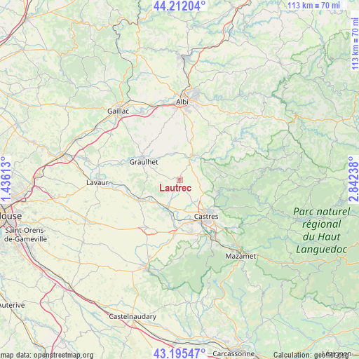
Lautrec GPS coordinates[2]
43° 42' 21.276" North, 2° 8' 21.3" East
| Map corner | latitude | longitude |
|---|---|---|
| Upper-left | 44.21204°, | 1.43613° |
| Center: | 43.70591°, | 2.13925° |
| Lower-right: | 43.19547°, | 2.84238° |
| Map W x H: | 113×113 km | = 70.2×70.2mi |
| max Lat: | 51.07786° ⇑90.3% North |
| Lautrec: | 43.70591° |
| min Lat: | ⇓9.7% South 41.3874° |
| min Long | Lautrec | max Long |
| -5.08615° | 2.13925° | 9.52242° |
| W 44.7%⇐ | ⇒55.3% E |
Elevation
Elevation of Lautrec is 296 m = 971 ft, and this is 102.3 m = 336 ft above average elevation for this country.
| Max E: |
2333 m = 7654 ft | 19.5% |
| Lautrec | 296 m 971 ft | |
| Avg. | 193.7 m = 635 ft | |
Min E: |
-1 m = -3 ft | 80.5% |
See also: France elevation on elevation.city.
Geographical zone
Lautrec is located in North temperate zone (between Tropic of Cancer and the Arctic Circle). Distance of this Northern Tropic circle is 2253.7 km =1400.4 mi to South.| Distance of | km | miles | from Lautrec |
|---|---|---|---|
| North Pole | 5147.4 | 3198.4 | to North |
| Arctic Circle | 2541.5 | 1579.2 | to North |
| Tropic Cancer | 2253.7 | 1400.4 | to South |
| Equator | 4859.6 | 3019.6 | to South |


Nearby cities:
15 places around Lautrec: (largest is in red/bold)
• Cambounet-sur-le-Sor
14.5 km =9 mi,  186°
186°
• Castres
13.8 km =8.6 mi,  143°
143°
• Damiatte
14.4 km =8.9 mi,  245°
245°
• Fréjeville
10.6 km =6.6 mi,  179°
179°
• Graulhet
13.8 km =8.6 mi,  299°
299°
• Lombers
10.5 km =6.5 mi,  4°
4°
• Montredon-Labessonnié
14.9 km =9.3 mi,  85°
85°
• Roquecourbe
13.2 km =8.2 mi,  110°
110°
• Réalmont
8.9 km =5.5 mi,  26°
26°
• Saint-Paul-Cap-de-Joux
14.7 km =9.1 mi,  243°
243°
• Saïx
14.1 km =8.8 mi,  165°
165°
• Serviès
10.2 km =6.3 mi, 240°
• Sémalens
12.8 km =8 mi, 189°
• Vielmur-sur-Agout
10.4 km =6.5 mi,  197°
197°
• Vénès
4.9 km =3 mi,  59°
59°
Sources, notices
• [Note1] Compared only with cities in France existing in our database
• [Src1] Map data: © OpenStreetMap contributors (CC-BY-SA)
• [Src2] Other city data from geonames.org with taken over terms of usage.
• [Src3] Geographical zone / Annual Mean Temperature by Robert A. Rohde @ Wikipedia
