Roquecourbe geodata
Roquecourbe (Occitanie) is a populated place; located in France in Europe/Paris (GMT+2) time zone. With population of 2,310 people, there are 4176 cities with bigger population in this country. Compared to other cities in France, 91% of cities are located further ↑North; 52.9% of cities are located further →East and 70.1% of cities have lower elevation than Roquecourbe. Note1
Administrative division(s):
- Level 1: Occitanie
- Level 2: Tarn
- Level 3: Arrondissement de Castres
- Level 4: Roquecourbe


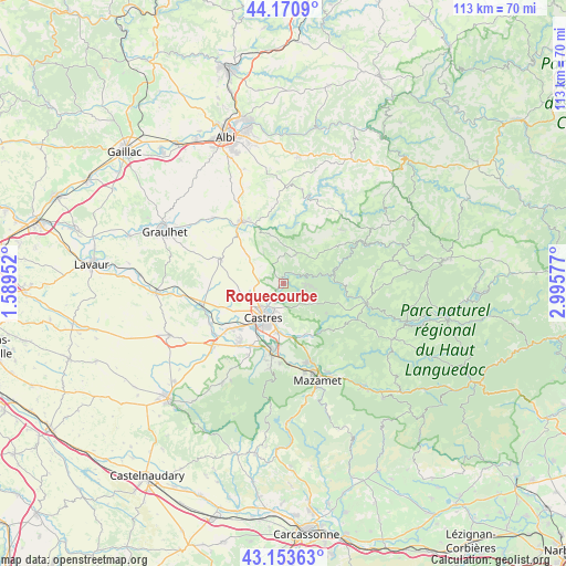
Roquecourbe GPS coordinates[2]
43° 39' 51.912" North, 2° 17' 33.504" East
| Map corner | latitude | longitude |
|---|---|---|
| Upper-left | 44.1709°, | 1.58952° |
| Center: | 43.66442°, | 2.29264° |
| Lower-right: | 43.15363°, | 2.99577° |
| Map W x H: | 113.1×113.1 km | = 70.3×70.3mi |
| max Lat: | 51.07786° ⇑91% North |
| Roquecourbe: | 43.66442° |
| min Lat: | ⇓9% South 41.3874° |
| min Long | Roquecourbe | max Long |
| -5.08615° | 2.29264° | 9.52242° |
| W 47.1%⇐ | ⇒52.9% E |
Elevation
Elevation of Roquecourbe is 220 m = 722 ft, and this is 26.3 m = 86 ft above average elevation for this country.
| Max E: |
2333 m = 7654 ft | 29.9% |
| Roquecourbe | 220 m 722 ft | |
| Avg. | 193.7 m = 635 ft | |
Min E: |
-1 m = -3 ft | 70.1% |
See also: France elevation on elevation.city.
Geographical zone
Roquecourbe is located in North temperate zone (between Tropic of Cancer and the Arctic Circle). Distance of this Northern Tropic circle is 2249.1 km =1397.5 mi to South.| Distance of | km | miles | from Roquecourbe |
|---|---|---|---|
| North Pole | 5152 | 3201.3 | to North |
| Arctic Circle | 2546.1 | 1582.1 | to North |
| Tropic Cancer | 2249.1 | 1397.5 | to South |
| Equator | 4855 | 3016.8 | to South |


Nearby cities:
15 places around Roquecourbe: (largest is in red/bold)
• Burlats
3.8 km =2.4 mi,  146°
146°
• Castres
7.8 km =4.8 mi,  213°
213°
• Fréjeville
13.6 km =8.5 mi,  243°
243°
• Lacrouzette
4.5 km =2.8 mi,  95°
95°
• Lagarrigue
9.7 km =6 mi,  187°
187°
• Lautrec
13.2 km =8.2 mi,  290°
290°
• Montredon-Labessonnié
6.4 km =4 mi,  23°
23°
• Navès
12.3 km =7.6 mi, 205°
• Noailhac
11.3 km =7 mi, 154°
• Payrin-Augmontel
14.2 km =8.8 mi,  159°
159°
• Saint-Salvy-de-la-Balme
10.4 km =6.5 mi,  124°
124°
• Saïx
12.6 km =7.8 mi,  224°
224°
• Vabre
11 km =6.8 mi,  74°
74°
• Valdurenque
10.6 km =6.6 mi,  173°
173°
• Vénès
10.8 km =6.7 mi,  311°
311°
Sources, notices
• [Note1] Compared only with cities in France existing in our database
• [Src1] Map data: © OpenStreetMap contributors (CC-BY-SA)
• [Src2] Other city data from geonames.org with taken over terms of usage.
• [Src3] Geographical zone / Annual Mean Temperature by Robert A. Rohde @ Wikipedia
