Vénès geodata
Vénès (Occitanie) is a populated place; located in France in Europe/Paris (GMT+2) time zone. With population of 614 people, there are 13088 cities with bigger population in this country. Compared to other cities in France, 90% of cities are located further ↑North; 54.6% of cities are located further →East and 76.1% of cities have lower elevation than Vénès. Note1
Administrative division(s):
- Level 1: Occitanie
- Level 2: Tarn
- Level 3: Arrondissement de Castres
- Level 4: Vénès


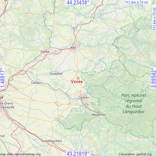
Vénès GPS coordinates[2]
43° 43' 42.384" North, 2° 11' 32.244" East
| Map corner | latitude | longitude |
|---|---|---|
| Upper-left | 44.23438°, | 1.48917° |
| Center: | 43.72844°, | 2.19229° |
| Lower-right: | 43.21819°, | 2.89542° |
| Map W x H: | 113×113 km | = 70.2×70.2mi |
| max Lat: | 51.07786° ⇑90% North |
| Vénès: | 43.72844° |
| min Lat: | ⇓10% South 41.3874° |
| min Long | Vénès | max Long |
| -5.08615° | 2.19229° | 9.52242° |
| W 45.4%⇐ | ⇒54.6% E |
Elevation
Elevation of Vénès is 257 m = 843 ft, and this is 63.3 m = 208 ft above average elevation for this country.
| Max E: |
2333 m = 7654 ft | 23.9% |
| Vénès | 257 m 843 ft | |
| Avg. | 193.7 m = 635 ft | |
Min E: |
-1 m = -3 ft | 76.1% |
See also: France elevation on elevation.city.
Geographical zone
Vénès is located in North temperate zone (between Tropic of Cancer and the Arctic Circle). Distance of this Northern Tropic circle is 2256.2 km =1401.9 mi to South.| Distance of | km | miles | from Vénès |
|---|---|---|---|
| North Pole | 5144.9 | 3196.9 | to North |
| Arctic Circle | 2539 | 1577.7 | to North |
| Tropic Cancer | 2256.2 | 1401.9 | to South |
| Equator | 4862.1 | 3021.2 | to South |


Nearby cities:
15 places around Vénès: (largest is in red/bold)
• Burlats
14.4 km =8.9 mi,  135°
135°
• Castres
14.2 km =8.8 mi,  164°
164°
• Dénat
13.2 km =8.2 mi,  4°
4°
• Fréjeville
13.7 km =8.5 mi,  197°
197°
• Graulhet
16.8 km =10.4 mi,  284°
284°
• Lacrouzette
14.7 km =9.1 mi,  121°
121°
• Lautrec
4.9 km =3 mi,  239°
239°
• Lombers
8.7 km =5.4 mi,  336°
336°
• Montredon-Labessonnié
10.7 km =6.6 mi,  96°
96°
• Roquecourbe
10.8 km =6.7 mi,  131°
131°
• Réalmont
5.5 km =3.4 mi,  357°
357°
• Saïx
16.2 km =10.1 mi,  182°
182°
• Serviès
15.2 km =9.4 mi, 239°
• Sémalens
16.5 km =10.3 mi, 203°
• Vielmur-sur-Agout
14.5 km =9 mi,  210°
210°
Sources, notices
• [Note1] Compared only with cities in France existing in our database
• [Src1] Map data: © OpenStreetMap contributors (CC-BY-SA)
• [Src2] Other city data from geonames.org with taken over terms of usage.
• [Src3] Geographical zone / Annual Mean Temperature by Robert A. Rohde @ Wikipedia
