Hellimer geodata
Hellimer (Grand Est) is a populated place; located in France in Europe/Paris (GMT+2) time zone. With population of 509 people, there are 15057 cities with bigger population in this country. Compared to other cities in France, 79.6% of cities are located further ↓South; 93.8% of cities are located further ←West and 74.8% of cities have lower elevation than Hellimer. Note1
Administrative division(s):
- Level 1: Grand Est
- Level 2: Moselle
- Level 3: Arrondissement de Forbach-Boulay-Moselle
- Level 4: Hellimer


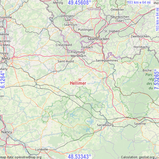
Hellimer GPS coordinates[2]
48° 59' 48.804" North, 6° 49' 46.272" East
| Map corner | latitude | longitude |
|---|---|---|
| Upper-left | 49.45608°, | 6.1264° |
| Center: | 48.99689°, | 6.82952° |
| Lower-right: | 48.53343°, | 7.53265° |
| Map W x H: | 102.6×102.6 km | = 63.8×63.8mi |
| max Lat: | 51.07786° ⇑20.4% North |
| Hellimer: | 48.99689° |
| min Lat: | ⇓79.6% South 41.3874° |
| min Long | Hellimer | max Long |
| -5.08615° | 6.82952° | 9.52242° |
| W 93.8%⇐ | ⇒6.2% E |
Elevation
Elevation of Hellimer is 247 m = 810 ft, and this is 53.3 m = 175 ft above average elevation for this country.
| Max E: |
2333 m = 7654 ft | 25.2% |
| Hellimer | 247 m 810 ft | |
| Avg. | 193.7 m = 635 ft | |
Min E: |
-1 m = -3 ft | 74.8% |
See also: France elevation on elevation.city.
Geographical zone
Hellimer is located in North temperate zone (between Tropic of Cancer and the Arctic Circle). Distance of this North polar circle is 1953.2 km =1213.7 mi to North.| Distance of | km | miles | from Hellimer |
|---|---|---|---|
| North Pole | 4559.1 | 2832.9 | to North |
| Arctic Circle | 1953.2 | 1213.7 | to North |
| Tropic Cancer | 2842 | 1765.9 | to South |
| Equator | 5447.9 | 3385.2 | to South |


Nearby cities:
15 places around Hellimer: (largest is in red/bold)
• Albestroff
7.4 km =4.6 mi,  164°
164°
• Altviller
11.1 km =6.9 mi,  320°
320°
• Barst
8 km =5 mi,  2°
2°
• Cappel
8.5 km =5.3 mi,  9°
9°
• Francaltroff
4.5 km =2.8 mi,  210°
210°
• Grostenquin
6.8 km =4.2 mi,  254°
254°
• Hilsprich
6.5 km =4 mi,  73°
73°
• Holving
10.1 km =6.3 mi,  80°
80°
• Insming
5.7 km =3.5 mi,  143°
143°
• Laning
5.9 km =3.7 mi, 316°
• Le Val-de-Guéblange
9.9 km =6.2 mi,  100°
100°
• Lixing-lès-Saint-Avold
7.1 km =4.4 mi,  307°
307°
• Rémering-lès-Puttelange
9 km =5.6 mi,  60°
60°
• Saint-Jean-Rohrbach
5.2 km =3.2 mi,  50°
50°
• Vahl-Ebersing
8.1 km =5 mi, 316°
Sources, notices
• [Note1] Compared only with cities in France existing in our database
• [Src1] Map data: © OpenStreetMap contributors (CC-BY-SA)
• [Src2] Other city data from geonames.org with taken over terms of usage.
• [Src3] Geographical zone / Annual Mean Temperature by Robert A. Rohde @ Wikipedia
