Grézieu-la-Varenne geodata
Grézieu-la-Varenne (Auvergne-Rhône-Alpes) is a populated place; located in France in Europe/Paris (GMT+2) time zone. With population of 4,369 people, there are 2254 cities with bigger population in this country. Compared to other cities in France, 70.1% of cities are located further ↑North; 73.6% of cities are located further ←West and 82.2% of cities have lower elevation than Grézieu-la-Varenne. Note1
Administrative division(s):
- Level 1: Auvergne-Rhône-Alpes
- Level 2: Département du Rhône
- Level 3: Arrondissement de Lyon
- Level 4: Grézieu-la-Varenne


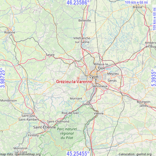
Grézieu-la-Varenne GPS coordinates[2]
45° 44' 50.496" North, 4° 41' 25.332" East
| Map corner | latitude | longitude |
|---|---|---|
| Upper-left | 46.23586°, | 3.98725° |
| Center: | 45.74736°, | 4.69037° |
| Lower-right: | 45.25455°, | 5.3935° |
| Map W x H: | 109.1×109.1 km | = 67.8×67.8mi |
| max Lat: | 51.07786° ⇑70.1% North |
| Grézieu-la-Varenne: | 45.74736° |
| min Lat: | ⇓29.9% South 41.3874° |
| min Long | Grézieu-la-Var | max Long |
| -5.08615° | 4.69037° | 9.52242° |
| W 73.6%⇐ | ⇒26.4% E |
Elevation
Elevation of Grézieu-la-Varenne is 312 m = 1024 ft, and this is 118.3 m = 388 ft above average elevation for this country.
| Max E: |
2333 m = 7654 ft | 17.8% |
| Grézieu-la-Varenne | 312 m 1024 ft | |
| Avg. | 193.7 m = 635 ft | |
Min E: |
-1 m = -3 ft | 82.2% |
See also: France elevation on elevation.city.
Geographical zone
Grézieu-la-Varenne is located in North temperate zone (between Tropic of Cancer and the Arctic Circle). Distance of this North polar circle is 2314.5 km =1438.2 mi to North.| Distance of | km | miles | from Grézieu-la-Varenne |
|---|---|---|---|
| North Pole | 4920.4 | 3057.4 | to North |
| Arctic Circle | 2314.5 | 1438.2 | to North |
| Tropic Cancer | 2480.7 | 1541.4 | to South |
| Equator | 5086.6 | 3160.7 | to South |


Nearby cities:
15 places around Grézieu-la-Varenne: (largest is in red/bold)
• Brindas
2.9 km =1.8 mi,  175°
175°
• Chaponost
5.8 km =3.6 mi,  135°
135°
• Charbonnières-les-Bains
5.7 km =3.5 mi,  49°
49°
• Chevinay
6.9 km =4.3 mi,  291°
291°
• Craponne
2.6 km =1.6 mi,  95°
95°
• Francheville
5.8 km =3.6 mi, 102°
• La Tour-de-Salvagny
7.7 km =4.8 mi,  15°
15°
• Messimy
5.6 km =3.5 mi,  192°
192°
• Pollionnay
3 km =1.9 mi,  310°
310°
• Saint-Genis-les-Ollières
3 km =1.9 mi,  68°
68°
• Sainte-Consorce
3.2 km =2 mi,  359°
359°
• Soucieu-en-Jarrest
7.8 km =4.8 mi,  172°
172°
• Tassin-la-Demi-Lune
7.6 km =4.7 mi,  83°
83°
• Vaugneray
2.8 km =1.7 mi,  248°
248°
• Écully
7.4 km =4.6 mi, 66°
Sources, notices
• [Note1] Compared only with cities in France existing in our database
• [Src1] Map data: © OpenStreetMap contributors (CC-BY-SA)
• [Src2] Other city data from geonames.org with taken over terms of usage.
• [Src3] Geographical zone / Annual Mean Temperature by Robert A. Rohde @ Wikipedia
