Gérardmer geodata
Gérardmer (Grand Est) is a populated place; located in France in Europe/Paris (GMT+2) time zone. With population of 10,084 people, there are 944 cities with bigger population in this country. Compared to other cities in France, 60.7% of cities are located further ↓South; 94.2% of cities are located further ←West and 96.3% of cities have lower elevation than Gérardmer. Note1
Administrative division(s):
- Level 1: Grand Est
- Level 2: Vosges
- Level 3: Arrondissement de Saint-Dié-des-Vosges
- Level 4: Gérardmer


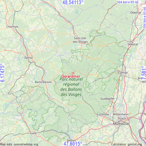
Gérardmer GPS coordinates[2]
48° 4' 24.456" North, 6° 52' 40.332" East
| Map corner | latitude | longitude |
|---|---|---|
| Upper-left | 48.54113°, | 6.17475° |
| Center: | 48.07346°, | 6.87787° |
| Lower-right: | 47.6015°, | 7.581° |
| Map W x H: | 104.5×104.5 km | = 64.9×64.9mi |
| max Lat: | 51.07786° ⇑39.3% North |
| Gérardmer: | 48.07346° |
| min Lat: | ⇓60.7% South 41.3874° |
| min Long | Gérardmer | max Long |
| -5.08615° | 6.87787° | 9.52242° |
| W 94.2%⇐ | ⇒5.8% E |
Elevation
Elevation of Gérardmer is 663 m = 2175 ft, and this is 469.3 m = 1540 ft above average elevation for this country.
| Max E: |
2333 m = 7654 ft | 3.7% |
| Gérardmer | 663 m 2175 ft | |
| Avg. | 193.7 m = 635 ft | |
Min E: |
-1 m = -3 ft | 96.3% |
See also: France elevation on elevation.city.
Geographical zone
Gérardmer is located in North temperate zone (between Tropic of Cancer and the Arctic Circle). Distance of this North polar circle is 2055.9 km =1277.5 mi to North.| Distance of | km | miles | from Gérardmer |
|---|---|---|---|
| North Pole | 4661.8 | 2896.7 | to North |
| Arctic Circle | 2055.9 | 1277.5 | to North |
| Tropic Cancer | 2739.3 | 1702.1 | to South |
| Equator | 5345.3 | 3321.4 | to South |


Nearby cities:
15 places around Gérardmer: (largest is in red/bold)
• Anould
13.4 km =8.3 mi,  22°
22°
• Basse-sur-le-Rupt
13.3 km =8.3 mi,  222°
222°
• Corcieux
11 km =6.8 mi,  1°
1°
• Cornimont
13.1 km =8.1 mi,  195°
195°
• Gerbépal
9 km =5.6 mi, 20°
• Granges-sur-Vologne
10.3 km =6.4 mi,  321°
321°
• La Bresse
8.3 km =5.2 mi,  186°
186°
• La Forge
11.5 km =7.1 mi,  265°
265°
• La Houssière
13.6 km =8.5 mi,  352°
352°
• Le Tholy
10 km =6.2 mi,  275°
275°
• Rochesson
8.9 km =5.5 mi,  229°
229°
• Sapois
11.2 km =7 mi,  237°
237°
• Vagney
14.1 km =8.8 mi, 237°
• Ventron
14.9 km =9.3 mi,  182°
182°
• Xonrupt-Longemer
4 km =2.5 mi,  75°
75°
Sources, notices
• [Note1] Compared only with cities in France existing in our database
• [Src1] Map data: © OpenStreetMap contributors (CC-BY-SA)
• [Src2] Other city data from geonames.org with taken over terms of usage.
• [Src3] Geographical zone / Annual Mean Temperature by Robert A. Rohde @ Wikipedia
