Broquiès geodata
Broquiès (Occitanie) is a populated place; located in France in Europe/Paris (GMT+2) time zone. With population of 710 people, there are 11647 cities with bigger population in this country. Compared to other cities in France, 87% of cities are located further ↑North; 53.4% of cities are located further ←West and 87.4% of cities have lower elevation than Broquiès. Note1
Administrative division(s):
- Level 1: Occitanie
- Level 2: Département de l'Aveyron
- Level 3: Arrondissement de Millau
- Level 4: Broquiès


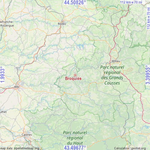
Broquiès GPS coordinates[2]
44° 0' 16.812" North, 2° 41' 47.148" East
| Map corner | latitude | longitude |
|---|---|---|
| Upper-left | 44.50826°, | 1.9933° |
| Center: | 44.00467°, | 2.69643° |
| Lower-right: | 43.49677°, | 3.39955° |
| Map W x H: | 112.5×112.5 km | = 69.9×69.9mi |
| max Lat: | 51.07786° ⇑87% North |
| Broquiès: | 44.00467° |
| min Lat: | ⇓13% South 41.3874° |
| min Long | Broquiès | max Long |
| -5.08615° | 2.69643° | 9.52242° |
| W 53.4%⇐ | ⇒46.6% E |
Elevation
Elevation of Broquiès is 380 m = 1247 ft, and this is 186.3 m = 611 ft above average elevation for this country.
| Max E: |
2333 m = 7654 ft | 12.6% |
| Broquiès | 380 m 1247 ft | |
| Avg. | 193.7 m = 635 ft | |
Min E: |
-1 m = -3 ft | 87.4% |
See also: France elevation on elevation.city.
Geographical zone
Broquiès is located in North temperate zone (between Tropic of Cancer and the Arctic Circle). Distance of this Northern Tropic circle is 2286.9 km =1421 mi to South.| Distance of | km | miles | from Broquiès |
|---|---|---|---|
| North Pole | 5114.2 | 3177.8 | to North |
| Arctic Circle | 2508.3 | 1558.6 | to North |
| Tropic Cancer | 2286.9 | 1421 | to South |
| Equator | 4892.9 | 3040.3 | to South |


Nearby cities:
15 places around Broquiès: (largest is in red/bold)
• Arvieu
21 km =13 mi,  352°
352°
• Belmont-sur-Rance
21.1 km =13.1 mi,  167°
167°
• Coupiac
10.7 km =6.6 mi,  238°
238°
• Curvalle
14.7 km =9.1 mi,  234°
234°
• Durenque
13.2 km =8.2 mi,  331°
331°
• La Selve
17.4 km =10.8 mi,  313°
313°
• Montlaur
17.6 km =10.9 mi,  141°
141°
• Réquista
13.3 km =8.3 mi,  283°
283°
• Saint-Affrique
16.4 km =10.2 mi,  109°
109°
• Saint-Rome-de-Cernon
21.5 km =13.4 mi,  87°
87°
• Saint-Rome-de-Tarn
16.7 km =10.4 mi,  73°
73°
• Saint-Sernin-sur-Rance
15.2 km =9.4 mi,  208°
208°
• Salles-Curan
21.1 km =13.1 mi,  20°
20°
• Viala-du-Tarn
16.4 km =10.2 mi,  62°
62°
• Villefranche-de-Panat
9.4 km =5.8 mi,  4°
4°
Sources, notices
• [Note1] Compared only with cities in France existing in our database
• [Src1] Map data: © OpenStreetMap contributors (CC-BY-SA)
• [Src2] Other city data from geonames.org with taken over terms of usage.
• [Src3] Geographical zone / Annual Mean Temperature by Robert A. Rohde @ Wikipedia
