Durenque geodata
Durenque (Occitanie) is a populated place; located in France in Europe/Paris (GMT+2) time zone. With population of 559 people, there are 14019 cities with bigger population in this country. Compared to other cities in France, 86.2% of cities are located further ↑North; 52.3% of cities are located further ←West and 96.8% of cities have lower elevation than Durenque. Note1
Administrative division(s):
- Level 1: Occitanie
- Level 2: Département de l'Aveyron
- Level 3: Arrondissement de Millau
- Level 4: Durenque


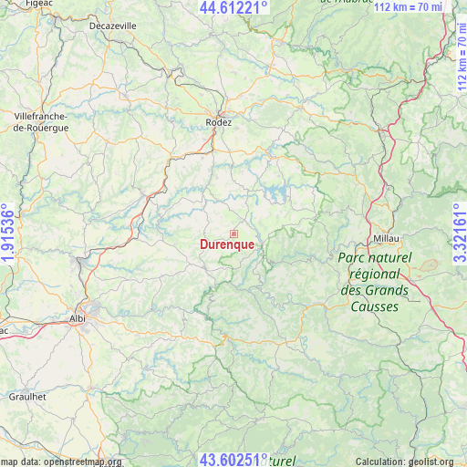
Durenque GPS coordinates[2]
44° 6' 34.272" North, 2° 37' 6.528" East
| Map corner | latitude | longitude |
|---|---|---|
| Upper-left | 44.61221°, | 1.91536° |
| Center: | 44.10952°, | 2.61848° |
| Lower-right: | 43.60251°, | 3.32161° |
| Map W x H: | 112.3×112.3 km | = 69.8×69.8mi |
| max Lat: | 51.07786° ⇑86.2% North |
| Durenque: | 44.10952° |
| min Lat: | ⇓13.8% South 41.3874° |
| min Long | Durenque | max Long |
| -5.08615° | 2.61848° | 9.52242° |
| W 52.3%⇐ | ⇒47.7% E |
Elevation
Elevation of Durenque is 715 m = 2346 ft, and this is 521.3 m = 1710 ft above average elevation for this country.
| Max E: |
2333 m = 7654 ft | 3.2% |
| Durenque | 715 m 2346 ft | |
| Avg. | 193.7 m = 635 ft | |
Min E: |
-1 m = -3 ft | 96.8% |
See also: France elevation on elevation.city.
Geographical zone
Durenque is located in North temperate zone (between Tropic of Cancer and the Arctic Circle). Distance of this Northern Tropic circle is 2298.6 km =1428.3 mi to South.| Distance of | km | miles | from Durenque |
|---|---|---|---|
| North Pole | 5102.5 | 3170.5 | to North |
| Arctic Circle | 2496.7 | 1551.4 | to North |
| Tropic Cancer | 2298.6 | 1428.3 | to South |
| Equator | 4904.5 | 3047.5 | to South |


Nearby cities:
15 places around Durenque: (largest is in red/bold)
• Arvieu
9.8 km =6.1 mi,  20°
20°
• Broquiès
13.2 km =8.2 mi,  151°
151°
• Calmont
17.7 km =11 mi,  331°
331°
• Cassagnes-Bégonhès
9.6 km =6 mi,  313°
313°
• Centrès
17.8 km =11.1 mi,  290°
290°
• Coupiac
17.6 km =10.9 mi,  189°
189°
• La Selve
6.4 km =4 mi,  273°
273°
• Lédergues
14.3 km =8.9 mi,  260°
260°
• Manhac
20 km =12.4 mi,  323°
323°
• Réquista
10.8 km =6.7 mi,  218°
218°
• Salles-Curan
15.8 km =9.8 mi,  59°
59°
• Salmiech
8.8 km =5.5 mi,  335°
335°
• Trémouilles
15.2 km =9.4 mi,  7°
7°
• Valence-d’Albigeois
19.8 km =12.3 mi,  239°
239°
• Villefranche-de-Panat
7.3 km =4.5 mi,  108°
108°
Sources, notices
• [Note1] Compared only with cities in France existing in our database
• [Src1] Map data: © OpenStreetMap contributors (CC-BY-SA)
• [Src2] Other city data from geonames.org with taken over terms of usage.
• [Src3] Geographical zone / Annual Mean Temperature by Robert A. Rohde @ Wikipedia
