Boussac geodata
Boussac (Nouvelle-Aquitaine) is a populated place; located in France in Europe/Paris (GMT+2) time zone. With population of 1,380 people, there are 6683 cities with bigger population in this country. Compared to other cities in France, 61.7% of cities are located further ↑North; 54.1% of cities are located further →East and 87.5% of cities have lower elevation than Boussac. Note1
Administrative division(s):
- Level 1: Nouvelle-Aquitaine
- Level 2: Creuse
- Level 3: Aubusson
- Level 4: Boussac


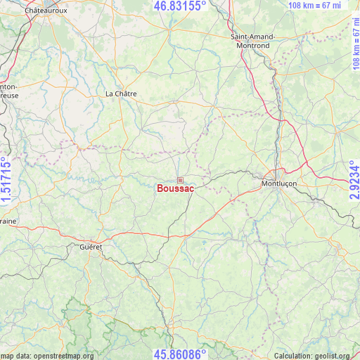
Boussac GPS coordinates[2]
46° 20' 54.096" North, 2° 13' 12.972" East
| Map corner | latitude | longitude |
|---|---|---|
| Upper-left | 46.83155°, | 1.51715° |
| Center: | 46.34836°, | 2.22027° |
| Lower-right: | 45.86086°, | 2.9234° |
| Map W x H: | 107.9×107.9 km | = 67×67mi |
| max Lat: | 51.07786° ⇑61.7% North |
| Boussac: | 46.34836° |
| min Lat: | ⇓38.3% South 41.3874° |
| min Long | Boussac | max Long |
| -5.08615° | 2.22027° | 9.52242° |
| W 45.9%⇐ | ⇒54.1% E |
Elevation
Elevation of Boussac is 381 m = 1250 ft, and this is 187.3 m = 615 ft above average elevation for this country.
| Max E: |
2333 m = 7654 ft | 12.5% |
| Boussac | 381 m 1250 ft | |
| Avg. | 193.7 m = 635 ft | |
Min E: |
-1 m = -3 ft | 87.5% |
See also: France elevation on elevation.city.
Geographical zone
Boussac is located in North temperate zone (between Tropic of Cancer and the Arctic Circle). Distance of this North polar circle is 2247.7 km =1396.7 mi to North.| Distance of | km | miles | from Boussac |
|---|---|---|---|
| North Pole | 4853.6 | 3015.9 | to North |
| Arctic Circle | 2247.7 | 1396.7 | to North |
| Tropic Cancer | 2547.5 | 1582.9 | to South |
| Equator | 5153.5 | 3202.2 | to South |


Nearby cities:
15 places around Boussac: (largest is in red/bold)
• Boussac-Bourg
1.8 km =1.1 mi,  37°
37°
• Châtelus-Malvaleix
15.8 km =9.8 mi,  252°
252°
• Clugnat
9.1 km =5.7 mi,  241°
241°
• Genouillac
17.5 km =10.9 mi,  271°
271°
• Gouzon
17.5 km =10.9 mi,  175°
175°
• Huriel
19.9 km =12.4 mi,  82°
82°
• Jarnages
21.2 km =13.2 mi,  209°
209°
• Moutier-Malcard
21.7 km =13.5 mi,  283°
283°
• Parsac
17.1 km =10.6 mi,  198°
198°
• Préveranges
9.8 km =6.1 mi,  15°
15°
• Saint-Martinien
19.3 km =12 mi,  94°
94°
• Saint-Silvain-Bas-le-Roc
2 km =1.2 mi,  161°
161°
• Sainte-Sévère-sur-Indre
19.2 km =11.9 mi,  323°
323°
• Soumans
8.4 km =5.2 mi,  128°
128°
• Vallière
19.7 km =12.2 mi,  118°
118°
Sources, notices
• [Note1] Compared only with cities in France existing in our database
• [Src1] Map data: © OpenStreetMap contributors (CC-BY-SA)
• [Src2] Other city data from geonames.org with taken over terms of usage.
• [Src3] Geographical zone / Annual Mean Temperature by Robert A. Rohde @ Wikipedia
